Old Kollau
| Old Kollau | ||
|
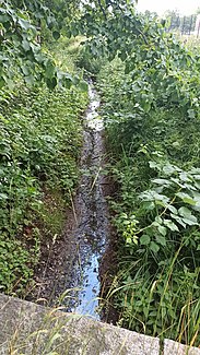
The Alte Kollau near the inflow through the Geelebek |
||
| Data | ||
| location | Hamburg - Lokstedt , Germany | |
| River system | Elbe | |
| Drain over | Kollau → Tarpenbek → Alster → Elbe → North Sea | |
| source | Hagendeel in Hamburg-Lokstedt 53 ° 36 ′ 26 ″ N , 9 ° 56 ′ 35 ″ E |
|
| muzzle | Kollau in Hamburg-Lokstedt Coordinates: 53 ° 36 '27 " N , 9 ° 57' 25" E 53 ° 36 '27 " N , 9 ° 57' 25" E
|
|
| length | 1 km | |
| Right tributaries | Geelebek | |
| Big cities | Hamburg | |
| Navigable | No | |
The Alte Kollau is a tributary of the Kollau in Hamburg-Lokstedt . Due to the planting, lack of paths and an access ban by the water authority, the stream is not accessible, but the source and the mouth can be seen.
course
The Alte Kollau rises east of the Hagendeel street just before the northern end of the street, where the Kollau also flows. From there it flows east and crosses under Alma-Ohlmann-Weg. From there to the next crossing, it runs parallel to Alma-Ohlmann-Weg.
Shortly before crossing under the Wehmerweg, the Geelebek , its only tributary, flows into the Alte Kollau. The inflow is not visible. It is not clear whether this is due to the dense growth or a piped inflow.
The Alte Kollau finally crosses under the Niendorfer Straße and then flows into the Kollau after crossing under the freight bypass.
Flood protection
Between the area at Hagendeel 60 and the Alte Kollau there is a flood area ( flood retention area ) with a capacity of approx. 900 m³ to the side of the Alte Kollau . There is also a bottom seal and a dam facing the Alte Kollau, “so that water can stand permanently in the floodplain. This, together with suitable planting, also improves the ecological condition of the old Kollau in terms of the EU Water Framework Directive ”, as it says on the Hamburg website about flood protection in the Kollau. Construction took place in the third quarter of 2018.
Web links
Individual evidence
- ↑ District Office Eimsbüttel - Flood Protection - FHH. Retrieved June 25, 2020 .
