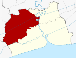
Ban Phaeo district
|
Ban Phaeo บ้านแพ้ว |
|
|---|---|
| Province: | Samut Sakhon |
| Surface: | 245.031 km² |
| Residents: | 95,014 (2013) |
| Population density : | 371 U / km² |
| ZIP : | 74120, 70210 |
| Geocode : | 7403 |
| map | |

|
|
Amphoe Ban Phaeo ( Thai : อำเภอ บ้านแพ้ว ) is a district ( Amphoe - administrative district) in the northern part of Samut Sakhon Province . The Samut Sakhon Province is located in the central region of Thailand .
geography
Samut Sakhon Province is located on the northern shore of the Gulf of Thailand .
Neighboring districts (clockwise from north): Sam Phran district of Nakhon Pathom province , Krathum Baen and Mueang Samut Sakhon district of Samut Sakhon province, Mueang Samut Songkhram district of Samut Songkhram province , and Damnoen Saduak and Bang Phae district of Ratchaburi province .
history
In the past, the area of today's Ban Phaeo was covered by dense forest. Hunters who hunted wild animals here often got lost, so certain meeting points were set up with the help of Phaeo flags (literally "scarecrows"). When the first village was founded here, the inhabitants called it "Ban Phaeo". It was administered by the Sam Phran district. When the village got big enough it became a tambon . In 1925, the government separated the Tambon Rong Khe and Lak Sam from Ban Bo and merged them with Tambon Ban Phaeo to form the Amphoe Ban Phaeo. The administration was transferred to the Samut Sakhon Province.
administration
Provincial Administration
The district of Ban Phaeo is divided into twelve tambon ("subdistricts" or "municipalities"), which are further subdivided into 97 muban ("villages").
| No. | Surname | Thai | Muban | Pop. |
|---|---|---|---|---|
| 1. | Ban Phaeo | บ้านแพ้ว | 10 | 10,591 |
| 2. | Lak Sam | หลัก สาม | 13 | 14,686 |
| 3. | Yokkrabat | ยกกระบัตร | 12 | 13,068 |
| 4th | Rong Khe | โรง เข้ | - | 12.114 |
| 5. | Nong Song Hong | หนองสองห้อง | - | 8,355 |
| 6th | Nong Bua | หนองบัว | 9 | 6,620 |
| 7th | Lak Song | หลัก สอง | 7th | 4,532 |
| 8th. | Chet Rio | เจ็ด ริ้ว | 5 | 3,846 |
| 9. | Khlong Tan | คลองตัน | 5 | 4,808 |
| 10. | Amphaeng | อำ แพง | 7th | 6,492 |
| 11. | Suan Som | สวน ส้ม | 5 | 5,142 |
| 12. | Kaset Phatthana | เกษตร พัฒนา | 5 | 4,760 |
Note: Some of the Muban's data are not yet available.
Local administration
There are three municipalities with "small town" status ( Thesaban Tambon ) in the district:
- Kaset Phatthana (Thai: เทศบาล ตำบล เกษตร พัฒนา ) consisting of the complete Tambon Kaset Phatthana and parts of the Tambon Khlong Tan.
- Ban Phaeo (Thai: เทศบาล ตำบล บ้านแพ้ว ) consisting of the parts of the tambon Ban Phaeo, Lak Sam.
- Lak Ha (Thai: เทศบาล ตำบล หลัก ห้า ) consisting of the complete tambon Yokkrabat, Rong Khe, Nong Song Hong, Nong Bua.
In addition, there are seven " Tambon Administration Organizations " ( องค์การ บริหาร ส่วน ตำบล - Tambon Administrative Organizations, TAO)
- Ban Phaeo (Thai: องค์การ บริหาร ส่วน ตำบล บ้านแพ้ว ) consisting of parts of the Tambon Ban Phaeo.
- Lak Sam (Thai: องค์การ บริหาร ส่วน ตำบล หลัก สาม ) consisting of parts of the Tambon Lak Sam.
- Lak Song (Thai: องค์การ บริหาร ส่วน ตำบล หลัก สอง ) consisting of the complete Tambon Lak Song.
- Chet Rio (Thai: องค์การ บริหาร ส่วน ตำบล เจ็ด ริ้ว ) consisting of the complete Tambon Chet Rio.
- Khlong Tan (Thai: องค์การ บริหาร ส่วน ตำบล คลองตัน ) consisting of parts of the Tambon Khlong Tan.
- Amphaeng (Thai: องค์การ บริหาร ส่วน ตำบล อำ แพง ) consisting of the complete tambon Amphaeng.
- Suan Som (Thai: องค์การ บริหาร ส่วน ตำบล สวน ส้ม ) consisting of the complete tambon Suan Som.
Individual evidence
- ↑ 2013 population statistics ( Thai ) Department of Provincial Administration. Retrieved August 10, 2014.
Web links
Coordinates: 13 ° 35 ' N , 100 ° 6' E