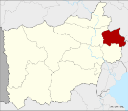
Bang Phae district
|
Bang Phae บางแพ |
|
|---|---|
| Province: | Ratchaburi |
| Surface: | 172.59 km² |
| Residents: | 44,651 (2013) |
| Population density : | 103.9 U / km² |
| ZIP : | 70160 |
| Geocode : | 7006 |
| map | |

|
|
Amphoe Bang Phae ( Thai : อำเภอ บางแพ ) is a district ( amphoe - administrative district) in the province of Ratchaburi . The Ratchaburi Province is located in the central region of Thailand .
geography
Neighboring districts (from the south clockwise) Amphoe Damnoen Saduak and Photharam of Ratchaburi province, the Amphoe Mueang Nakhon Pathom and Sam Phran the province of Nakhon Pathom and ban phaeo district of Samut Sakhon .
history
The district was set up in 1914 from 17 tambon from Ban Pong , Photharam and Damnoen Saduak, initially as a "branch circle" ( King Amphoe ) . In 1917 it was given full amphoe status. At that time the administration building was located in a pavilion of Wat Hua Pho in Tambon Hua Pho. Hence the district was first named Hua Pho. In 1918 a permanent administration building was opened in Tambon Bang Phae on the eastern bank of the Bang Phae Canal ( Khlong Bang Phae) . In 1939 the district was finally named Bang Phae.
archeology
- Khok Phlap - archaeological site between the Chao Phraya and Mae Klong rivers.
administration
Provincial Administration
Bang Phae County is divided into seven tambon ("subdistricts" or "parishes"), which are further divided into 65 muban ("villages").
| No. | Surname | Thai | Muban | Pop. |
|---|---|---|---|---|
| 1. | Bang Phae | บางแพ | 11 | 8,253 |
| 2. | Wang Yen | วัง เย็น | 10 | 7,832 |
| 3. | Hua Pho | หัว โพ | 6th | 4,714 |
| 4th | Wat Kaeo | วัด แก้ว | 11 | 5,798 |
| 5. | Don Yai | ดอน ใหญ่ | 9 | 3,879 |
| 6th | Don Kha | ดอน คา | 7th | 3,533 |
| 7th | Pho Hak | โพ หัก | 11 | 10,642 |
Local administration
There are two municipalities with "small town" status ( Thesaban Tambon ) in the district:
- Bang Phae (Thai: เทศบาล ตำบล บางแพ ) consisting of the complete tambon Bang Phae, Wang Yen.
- Pho Hak (Thai: เทศบาล ตำบล โพ หัก ) consisting of the complete Tambon Pho Hak.
There are also four " tambon administration organizations " ( องค์การ บริหาร ส่วน ตำบล - Tambon Administrative Organizations, TAO)
- Hua Pho (Thai: องค์การ บริหาร ส่วน ตำบล หัว โพ ) consisting of the complete Tambon Hua Pho.
- Wat Kaeo (Thai: องค์การ บริหาร ส่วน ตำบล วัด แก้ว ) consisting of the complete tambon Wat Kaeo.
- Don Yai (Thai: องค์การ บริหาร ส่วน ตำบล ดอน ใหญ่ ) consisting of the complete tambon Don Yai.
- Don Kha (Thai: องค์การ บริหาร ส่วน ตำบล ดอน คา ) consisting of the complete tambon Don Kha.
Individual evidence
- ↑ แจ้ง ความ กระทรวง มุรธา ธร เรื่อง ตั้ง อำเภอ ลำ พระยา ใน เมือง ราชบุรี . In: Royal Gazette . 31, No. 0 ง , November 8, 1914, p. 1789.
- ↑ ประกาศ กระทรวง มหาดไทย เรื่อง เปลี่ยน ชื่อ อำเภอ . In: Royal Gazette . 34, No. 0 ก , April 29, 1917, pp. 40-68.
- ↑ พระราชกฤษฎีกา เปลี่ยน นาม อำเภอ กิ่ง อำเภอ และ ตำบล บาง แห่ง พุทธศักราช ๒๔๘๒ . In: Royal Gazette . 56, No. 0 ก , April 17, 1939, pp. 354-364.
- ↑ 2013 population statistics ( Thai ) Department of Provincial Administration. Retrieved September 12, 2014.
Web links
- More information about Bang Phae from amphoe.com (in Thai). Archived from the original on September 18, 2010 ; accessed on July 30, 2015 .
Coordinates: 13 ° 42 ' N , 99 ° 56' E
