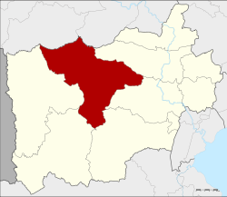
Chom Bueng district
|
Chom Bueng จอมบึง |
|
|---|---|
| Province: | Ratchaburi |
| Surface: | 772.1 km² |
| Residents: | 61,925 (2013) |
| Population density : | 75.2 U / km² |
| ZIP : | 70150 |
| Geocode : | 7002 |
| map | |

|
|
Amphoe Chom Bueng ( Thai : อำเภอ จอมบึง ) is a district ( amphoe - administrative district) in the province of Ratchaburi . The Ratchaburi Province is located in the central region of Thailand .
geography
Neighboring districts (from north clockwise): Amphoe Dan Makham Tia and Tha Muang of Kanchanaburi province and Amphoe Photharam , Mueang Ratchaburi , Pak Tho , Ban Kha and Suan Phueng Ratchaburi Province.
There are several caves in the district. The Khao-Bin Cave is said to be the most beautiful, there are many stalactites and stalagmites as well as a sacred lake. The cave is named after a rock formation that looks like a flying bird. When King Chulalongkorn (Rama V) visited the province in 1895, he gave the Chomphon Cave its name because a stalactite resembled a field marshal's epaulette .
history
King Chulalongkorn (Rama V) and Queen Saovabha visited Ratchaburi Province in 1895, including Chom Bueng County. When the king saw a beautiful, large lake, he named the district Great Lake or Chom Bueng and made it a "branch circle" ( King Amphoe ) .
In 1958, Chom Bueng was given full amphoe status.
education
Muban Chom Bueng Rajabhat University is located in Amphoe Chom Bueng .
administration
Provincial Administration
The district of Chom Bueng is divided into six tambon ("subdistricts" or "municipalities"), which are further divided into 89 muban ("villages").
| No. | Surname | Thai | Muban | Pop. |
|---|---|---|---|---|
| 1. | Chom Bueng | จอมบึง | 13 | 14,805 |
| 2. | Pak Chong | ปากช่อง | 15th | 9,483 |
| 3. | Boek Phrai | เบิกไพร | 11 | 5,860 |
| 4th | Dan Thap Tako | ด่าน ทับ ตะโก | 20th | 13.208 |
| 5. | Kaem On | แก้ม อ้น | 15th | 9,479 |
| 6th | Rank Bua | ราง บัว | 15th | 9,090 |
Local administration
There are two municipalities with "small town" status ( Thesaban Tambon ) in the district:
- Chom Bueng (Thai: เทศบาล ตำบล จอมบึง ) consisting of parts of the Tambon Chom Bueng.
- Dan Thap Tako (Thai: เทศบาล ตำบล ด่าน ทับ ตะโก ) consisting of parts of the Tambon Dan Thap Tako.
In addition, there are six " tambon administration organizations " ( องค์การ บริหาร ส่วน ตำบล - Tambon Administrative Organizations, TAO)
- Chom Bueng (Thai: องค์การ บริหาร ส่วน ตำบล จอมบึง ) consisting of parts of the Tambon Chom Bueng.
- Pak Chong (Thai: องค์การ บริหาร ส่วน ตำบล ปากช่อง ) consisting of the complete Tambon Pak Chong.
- Boek Phrai (Thai: องค์การ บริหาร ส่วน ตำบล เบิกไพร ) consisting of the complete tambon Boek Phrai.
- Dan Thap Tako (Thai: องค์การ บริหาร ส่วน ตำบล ด่าน ทับ ตะโก ) consisting of parts of the Tambon Dan Thap Tako.
- Kaem On (Thai: องค์การ บริหาร ส่วน ตำบล แก้ม อ้น ) consisting of the complete Tambon Kaem On.
- Rang Bua (Thai: องค์การ บริหาร ส่วน ตำบล ราง บัว ) consisting of the complete tambon Rang Bua.
Individual evidence
- ↑ 2013 population statistics ( Thai ) Department of Provincial Administration. Retrieved September 12, 2014.
Web links
- More information about Chom Bueng from amphoe.com (in Thai). Archived from the original on September 18, 2010 ; accessed on July 30, 2015 .
Coordinates: 13 ° 37 ' N , 99 ° 36' E


