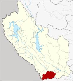
Dan Makham Tia district
|
Dan Makham Tia ด่าน มะขาม เตี้ย |
|
|---|---|
| Province: | Kanchanaburi |
| Surface: | 807.1 km² |
| Residents: | 33,542 (2013) |
| Population density : | 40 U / km² |
| ZIP : | 71260 |
| Geocode : | 7111 |
| map | |

|
|
Amphoe Dan Makham Tia ( Thai : อำเภอ ด่าน มะขาม เตี้ย ) is a district ( Amphoe - Administrative District) in the southern part of Kanchanaburi Province . Kanchanaburi Province is located in the western part of the central region of Thailand on the border with Myanmar .
geography
The neighboring counties are (clockwise from north): Amphoe Mueang Kanchanaburi and Amphoe Tha Muang of Kanchanaburi Province and Amphoe Chom Bueng and Suan Phueng of Ratchaburi Province .
The main water resources are the Mae Nam Khwae Noi (Khwae Noi River) and the Mae Nam Phachi (Phachi River) .
history
The area of Dan Makham Tia was a village for over 200 years, which was the border between the Mueang Kanchanaburi and Burma . In the past there were small Makham trees ( tamarind trees ) here , so the village first became “Ban Nong Makham Tia”. It was later renamed Dan Makham Tia.
The district was first created on April 1, 1990 as a "branch district" ( King Amphoe ) by separating the three Tambon Dan Makham Tia, Klondo and Chorakhe Phueak from the Mueang Kanchanaburi district . On September 8, 1995, Dan Makham Tia was granted full Amphoe status.
economy
- Selected OTOP products from the district
- Sato ( สาโท ) - alcoholic drink made from sticky rice
- Salt Duck Eggs ( ไข่เค็ม สมุนไพร )
- Asparagus ( Asparagus officinalis Linn. )
- Leather products (men's shoes, hats)
administration
Provincial Administration
Dan Makham Tia County is divided into four tambon ("subdistricts" or "parishes"), which are further subdivided into 41 muban ("villages").
| No. | Surname | Thai | Muban | Pop. |
|---|---|---|---|---|
| 1. | Dan Makham Tia | ด่าน มะขาม เตี้ย | 12 | 11.209 |
| 2. | Klondo | กลอน โด | 11 | 7,837 |
| 3. | Chorakhe Phueak | จร เข้ เผือก | 12 | 10,639 |
| 4th | Nong Phai | หนองไผ่ | 6th | 3,857 |
Local administration
There is one municipality with "small town" status ( Thesaban Tambon ) in the district:
- Dan Makham Tia (Thai: เทศบาล ตำบล ด่าน มะขาม เตี้ย ) consisting of parts of the Tambon Dan Makham Tia.
There are also four " tambon administration organizations " ( องค์การ บริหาร ส่วน ตำบล - Tambon Administrative Organizations, TAO)
- Dan Makham Tia (Thai: องค์การ บริหาร ส่วน ตำบล ด่าน มะขาม เตี้ย ) consisting of parts of the tambon Dan Makham Tia.
- Klondo (Thai: องค์การ บริหาร ส่วน ตำบล กลอน โด ) consisting of the complete tambon Klondo.
- Chorakhe Phueak (Thai: องค์การ บริหาร ส่วน ตำบล จร เข้ เผือก ) consisting of the complete tambon Chorakhe Phueak.
- Nong Phai (Thai: องค์การ บริหาร ส่วน ตำบล หนองไผ่ ) consisting of the complete Tambon Nong Phai.
Individual evidence
- ↑ ประกาศ กระทรวง มหาดไทย เรื่อง แบ่ง เขต ท้องที่ อำเภอ เมือง กาญจนบุรี จังหวัด กาญจนบุรี ตั้ง เป็น กิ่ง อำเภอ ด่าน มะขาม เตี้ย Royal Gazette, Vol. 103, Issue 25 ง of February 13, 1990, p. 1347 (in Thai)
- ↑ พระราชกฤษฎีกา ตั้ง อำเภอ ด่าน มะขาม เตี้ย อำเภอ แก่ง หาง แมว อำเภอ ภักดี ชุมพล อำเภอ เวียง แก่น อำเภอ แม่ วาง อำเภอ ถ้ำ พรรณ รา อำเภอ บ่อ เกลือ อำเภอ อำเภอ โนน สุวรรณ อำเภอ ห้วย ราช อำเภอ แม่ ลาน อำเภอ บางแก้ว อำเภอ ป่า พะยอม อำเภอ หนอง ม่วง ไข่ สุ ราช สี สี สี สี สี สี สี อำเภอ จัง หาร อำเภอ บ้าน ธิ อำเภอ ภู สิงห์ อำเภอ บาง กล่ำ อำเภอ วัง ม่วง และ อำเภอ นา ยูง พ.ศ. ๒๕๓๘ Royal Gazette, Vol. 112, Issue 32 ก August 8, 1995, pp. 1–3 (in Thai)
- ↑ Examples of the district's OTOP (in Thai)
- ↑ 2013 population statistics ( Thai ) Department of Provincial Administration. Retrieved September 10, 2014.
Web links
- More information on the Dan Makham Tia district from amphoe.com (in Thai; last accessed December 1, 2015)
Coordinates: 13 ° 51 ' N , 99 ° 25' E
