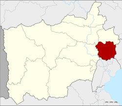
Damnoen Saduak district
|
Damnoen Saduak ดำเนินสะดวก |
|
|---|---|
| Province: | Ratchaburi |
| Surface: | 210.3 km² |
| Residents: | 94,589 (2013) |
| Population density : | 470.7 U / km² |
| ZIP : | 70130, 70210 |
| Geocode : | 7004 |
| map | |

|
|
Amphoe Damnoen Saduak ( Thai : อำเภอ ดำเนินสะดวก , lit. Comfortable Travel ) is a district ( Amphoe - administrative district) in the province of Ratchaburi . The Ratchaburi Province is located in the central region of Thailand .
geography
Neighboring circles (clockwise from east): Ban Phaeo district in Samut Sakhon Province , Mueang Samut Songkhram and Bang Khonthi district in Samut Songkhram Province, and Mueang Ratchaburi , Photharam and Bang Phae district in Ratchaburi Province.
Damnoen Saduak is located on the "Khlong Damnoen Saduak", a canal ( Khlong ) that connects the Mae Nam Tha Chin (Tha Chin River) with the Mae Nam Mae Klong (Mae Klong River).
Attractions
Damnoen Saduak is known for its floating market, which is held every morning on a khlong not far from the District Office . But since the market became a tourist attraction due to its proximity to Bangkok, it has lost much of its authenticity.
administration
Provincial Administration
Damnoen Saduak County is divided into 13 tambon ("subdistricts" or "parishes"), which are further subdivided into 105 muban ("villages").
| No. | Surname | Thai | Muban | Pop. |
|---|---|---|---|---|
| 1. | Damnoen Saduak | ดำเนินสะดวก | 10 | 7,607 |
| 2. | Prasat Sit | ประสาท สิทธิ์ | 6th | 7,779 |
| 3. | Si Surat | ศรี สุ ราษฎร์ | 8th | 6,027 |
| 4th | Ta Luang | ตา หลวง | 6th | 3,606 |
| 5. | Don Kruai | ดอน กรวย | 12 | 15,370 |
| 6th | Don Khlang | ดอน คลัง | 5 | 4,937 |
| 7th | Bua Ngam | บัว งาม | 6th | 4,313 |
| 8th. | Ban Rai | บ้านไร่ | 8th | 10,501 |
| 9. | Phaengphuai | แพงพวย | 12 | 8,964 |
| 10. | Si Muen | สี่ หมื่น | 8th | 3,100 |
| 11. | Tha Nat | ท่า นัด | 8th | 7,948 |
| 12. | Khun Phithak | ขุน พิทักษ์ | 9 | 7,030 |
| 13. | Don Phai | ดอน ไผ่ | 7th | 7,407 |
Local administration
There are five municipalities with "small town" status ( Thesaban Tambon ) in the district:
- Prasat Sit (Thai: เทศบาล ตำบล ประสาท สิทธิ์ ) consisting of parts of the Tambon Prasat Sit.
- Bua Ngam (Thai: เทศบาล ตำบล บัว งาม ) consisting of the complete tambon Bua Ngam.
- Damnoen Saduak (Thai: เทศบาล ตำบล ดำเนินสะดวก ) consisting of the complete tambon Damnoen Saduak and the parts of the tambon Si Surat, Ta Luang, Si Muen, Tha Nat.
- Si Don Phai (Thai: เทศบาล ตำบล ศรี ดอน ไผ่ ) consisting of the parts of the Tambon Prasat Sit, Si Surat, Don Phai.
- Ban Rai (Thai: เทศบาล ตำบล บ้านไร่ ) consisting of the complete tambon Ban Rai.
In addition, there are eight " tambon administration organizations " ( องค์การ บริหาร ส่วน ตำบล - Tambon Administrative Organizations, TAO)
- Ta Luang (Thai: องค์การ บริหาร ส่วน ตำบล ตา หลวง ) consisting of parts of the tambon Ta Luang.
- Don Kruai (Thai: องค์การ บริหาร ส่วน ตำบล ดอน กรวย ) consisting of the complete tambon Don Kruai.
- Don Khlang (Thai: องค์การ บริหาร ส่วน ตำบล ดอน คลัง ) consisting of the complete tambon Don Khlang.
- Phaengphuai (Thai: องค์การ บริหาร ส่วน ตำบล แพงพวย ) consisting of the complete tambon Phaengphuai.
- Si Muen (Thai: องค์การ บริหาร ส่วน ตำบล สี่ หมื่น ) consisting of parts of the Tambon Si Muen.
- Tha Nat (Thai: องค์การ บริหาร ส่วน ตำบล ท่า นัด ) consisting of parts of the Tambon Tha Nat.
- Khun Phithak (Thai: องค์การ บริหาร ส่วน ตำบล ขุน พิทักษ์ ) consisting of the complete Tambon Khun Phithak.
- Don Phai (Thai: องค์การ บริหาร ส่วน ตำบล ดอน ไผ่ ) consisting of parts of the Tambon Don Phai.
Individual evidence
- ↑ 2013 population statistics ( Thai ) Department of Provincial Administration. Retrieved September 12, 2014.
Web links
- More information on Amphoe Damnoen Saduak from amphoe.com (in Thai). Archived from the original on September 18, 2010 ; accessed on July 30, 2015 .
Coordinates: 13 ° 31 ' N , 99 ° 58' E

