Anakapalli
| Anakapalli | ||
|---|---|---|
|
|
||
| State : |
|
|
| State : | Andhra Pradesh | |
| District : | Visakhapatnam | |
| Location : | 17 ° 41 ′ N , 83 ° 0 ′ E | |
| Height : | 29 m | |
| Residents : | 86,519 (2011) | |
Anakapalli , also Anakapalle , is a city in the Indian state of Andhra Pradesh . It is part of the Visakhapatnam agglomeration .
The city is part of the Visakhapatnam district . Anakapalli has the status of a municipality . The city is divided into 20 wards (constituencies).
Demographics
The city's population is 86,519, according to the 2011 census. Anakapalli has a gender ratio of 1007 women per 1000 men and thus a rare excess of women for India. The literacy rate was 81.1% in 2011. Almost 97% of the population are Hindus , around 2% are Muslims and around 1% belong to another or no religion. 9.0% of the population are children under 6 years of age.
economy
Nearby is sugar cane grown and the city is known for its jaggery market, which second largest in India.
Infrastructure
The city is connected to the national rail and road network via its own train station and a national highway .
Attractions
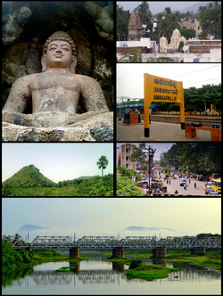
Sankaram , one of the most important Buddhist sites in Andhra Pradesh, is about 3.5 km from Anakapalle. Sankaram is famous for its numerous votive stupas, rock caves, masonry structures, prehistoric pottery and Satavahana coins from the 1st century AD.
Individual evidence
- ↑ www.census2011.co.in
- ↑ Anakapalle Municipality City Population Census 2011-2019 | Andhra Pradesh. Retrieved October 7, 2019 .

