
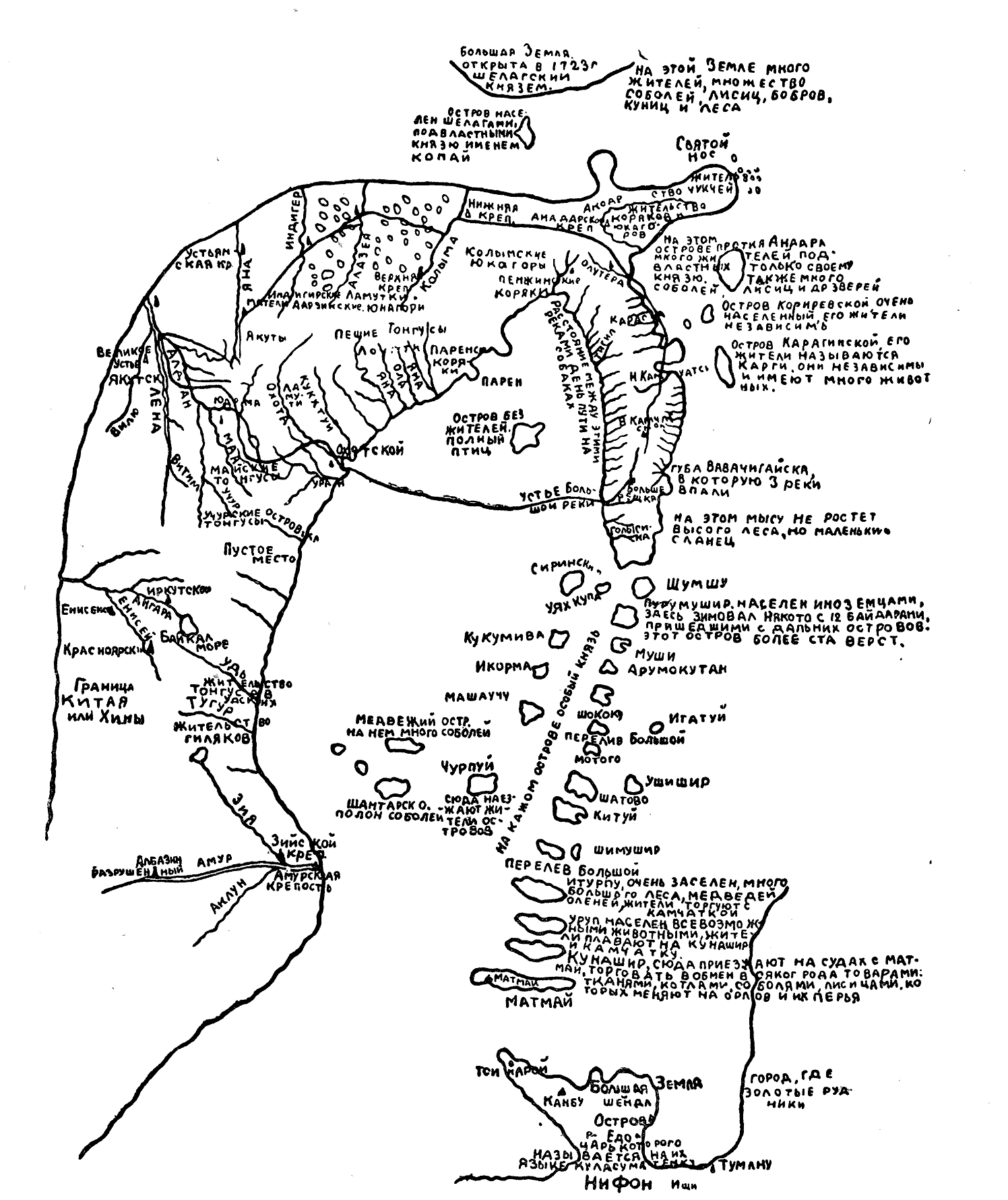
Andreevland
_p1.038_THE_EASTERN_PART_OF_SIBERIA.jpg)
Andreevland ( Russian Земля Андреева , Semlja Andrejewa) is a phantom island in the East Siberian Sea , which was adopted northeast of the Bear Islands . It is named after Stepan Andrejew, who led an expedition to the Bear Islands in 1763/64 and reported that he might have seen more land in the north. Andrejewland was marked on many maps until the 19th century and searched until the 20th century.
Creation of the legend
When the Russians to North Eastern Siberia came, they heard of the resident Chukchi by a "great country" both east of Anadyr- , and north of Kolymamündung . On the map of Eastern Siberia, which Afanassi Shestakov brought to Saint Petersburg in 1725 , one of the bear islands was marked with the name "Kopai" and two days' journey further north was a large country called "Tikigen", which is inhabited by the "Chrachai" people. It was not until 1763 that Friedrich Plenisner , at that time the commander of the Anadyrski Ostrog , sent an expedition under the direction of Stepan Andrejew to explore the islands north of the Kolyma estuary. Andreev drove from Nizhnekolymsk to the Kolyma estuary by dog sledding and reached the Bear Islands across the frozen sea. There he found signs everywhere that these had been inhabited earlier. Since the expedition ran out of food for the dogs, he returned to the mainland after a few days. In his diary, which he handed to Plenisner, it is recorded that he saw something blue in the distance from the island of Cheetyrjochstolbowoi, perhaps land or open water. In 1764 Andreev returned to the islands. In his diary, not published by Plenisner, it is said that he drove the sledge 550 werst (587 km) to an unknown island, but turned back 20 werst off its coast. From this point on, this country was found on the maps as Andreevland.
Expeditions in search of Andreevland
Andreyev's report was at least partly responsible for sending further expeditions to the area. The first took place from 1767 to 1771. Nikolai Daurkin , a Chukchi who was abducted by the Russians as a child but had received a good education in the house of Dmitri Pawluzki , traveled with geodesists I. Leontjew, I. Lyssow and A. Pushkarev to the Bear Islands to measure them and with them this opportunity to look out for Andreevland. The survey was very accurate for its time, no further land north of the Bear Islands was found.
The secret geographic and astronomical expedition, which was ordered by Catherine II in 1785 and lasted until 1795, led by Joseph Billings and Gavriil Sarychev , with the aim of creating an accurate map of Eastern Siberia and all the offshore islands, had also been instructed to go to Andreevland looking but couldn't find anything.
In 1810, after exploring the New Siberian Islands , Mathias von Hedenström set out from New Siberia in an easterly direction to look for Andreevland. After about 80 km, however, he had to turn back because he came across the open water of a polynya . He later made a second attempt from Cape Bolshoi Baranow and advanced more than 150 miles to the north without sighting any land.
After Ferdinand von Wrangel's expedition to survey the Siberian north coast east of the Indigirka from 1820 to 1824, which also served to search for Andreevland, it was proven that this did not exist at least at the point where Andreev's report had been expected. Instead, based on stories from the locals, Wrangel had come to believe that further east there could be a still undiscovered land, Wrangel Island , which was actually discovered in 1849. Andreevland now disappeared from the maps.
Nevertheless, the Russian Hydrographic Expedition from 1910 to 1915 was still concerned with the question of the existence of Andreyevland. Although there were again no signs of this, the area in question was still considered the least explored region of the Siberian north coast. In 1931, the Aeroarctic's research assignment for the LZ 127 Graf Zeppelin airship included searching for Andreevland on its Arctic voyage.
literature
- Н. Н. Зубов, К. С. Бадигин: Разгадка тайны Земли Андреева. In: Природа, 2/1952, pp. 37–45 (Russian, online ).
- Nikolai Alexander von Transehe : The Siberian Sea Road. The Work of the Russian Hydrographical Expedition to the Arctic 1910-1915 . In: Geographical Review . tape 15 , no. 3 , 1925, p. 367–398 (English, digital version [PDF; 10.0 MB ]).
Individual evidence
- ↑ Special news about the Chukchi headland and neighboring islands . In: New Nordic contributions to the physical and geographical description of earth and peoples, natural history and economics . Volume 1, 1781, pp. 245-248 ( digitized version ).
- ↑ see Shestakov's map in Зубов, К. С. Бадигин: Разгадка тайны Земли Андреева, 1952.
- ^ Adolf Erik Nordenskiöld: The circumnavigation of Asia and Europe on the Vega with a historical review of earlier journeys along the north coast of the Old World , second volume, Brockhaus, Leipzig 1882, p. 196 ff.
- ↑ a b Transehe: The Siberian Sea Road. The Work of the Russian Hydrographical Expedition to the Arctic 1910-1915 , 1925.
- ↑ a b Зубов, К. С. Бадигин: Разгадка тайны Земли Андреева, 1952
- ↑ Lisa von Engelhardt: Ferdinand von Wrangel and his journey along the north coast of Siberia and on the Arctic Ocean . Duncker & Humblot, Leipzig 1885, p. 14 f.
- ↑ “Should the time available allow a further advance to the east, it would be of great importance that the area between the New Siberian Islands and Wrangel Island i. to search for further land masses, especially for Andreev Land, which is said to be between 72 ° and 73 ° N. and 165 ° and 175 ° E. and ii. to determine the boundary of the continental shelf. ”See: Barbara Schennerlein: The aerophotogrammetric research program of the Arctic flight of the airship“ Graf Zeppelin ”LZ 127 in 1931 . In: Polar Research . Volume 84, No. 2, 2014, pp. 67-92. doi: 10.2312 / polar research. 84.2.67