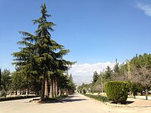
Anjar
Anjar ( Arabic عنجر, DMG ʿAnǧar , Armenian : Անճար ), also known as Haoush Mousa (حوش موسى, DMG Ḥauš Mūsā ), is a small town in Lebanon about 60 kilometers east of Beirut . Anjar has about 2400 inhabitants, most of whom are Armenians .
The modern place
Anjar is close to the highway that connects Beirut with Damascus , around ten kilometers from the Syrian border. The modern Anjar was founded in 1939 with the support of the French colonial power by several thousand Armenians from Musa Dagh ( Hatay province in Turkey ) who survived the genocide of the Armenians by the Young Turks. The six districts are named after the six villages of Musa Dagh.
The six districts of Anjar are called:
- Haji Hababli
- Kabusia
- Vakif
- Khodr Bek
- Yoghun Oluk
- Bitias
Even today, almost all 2400 inhabitants are Armenians who speak a Western Armenian dialect and the majority belong to the Armenian Apostolic Church , and to a lesser extent to the Armenian Catholic Church and the Armenian Evangelical Church . There are three denominational Armenian schools in Anjar. During the stationing of the Syrian armed forces in Lebanon between 1976 and 2005, Anjar was the headquarters of the Syrian secret service in Lebanon.
The ancient settlement
Next to the modern settlement are the remains of an Umayyad city, which was founded by Al-Walid I at the beginning of the 8th century, but remained unfinished. The place was soon abandoned after the last Syrian Umayyad caliph Marwan II defeated his rival Ibrahim in 744 at the gates of the city, which was obviously damaged.
The place was a fortress called Gerrha in classical antiquity. The remains of the city that can be seen today, the excavation of which began in 1943, are well preserved. They come from early Islamic times. The city comprised a north-south oriented rectangle of 370 × 310 meters, which was surrounded by a city wall. Two main streets ( Decumanus and Cardo ) crossed the settlement in a cross and connected four city gates. The streets were decorated with colonnades and lined with around 600 shops. The three main buildings were the large palace in the south, the small palace in the north and a mosque between the two palaces. Other public buildings were a bath and a tetrapylon . The current appearance of the city, especially the so-called North Palace, has been distorted by extensive restoration measures.
The city is considered to be one of the best examples of early Islamic urban planning. Strong Byzantine influences can still be observed in the architecture and the city map. Therefore, the place belongs since 1984 to the World Heritage of UNESCO .
Web links
- Entry on the UNESCO World Heritage Center website ( English and French ).
- Photos
- An Umayyad site of Lebanon
Individual evidence
- ↑ Geography and Demographics of Anjar. In: mousaler.com . Retrieved August 3, 2020.
- ↑ Lebanon: Karame's Surprise . Frankfurter Allgemeine Zeitung website from March 1, 2005. Accessed July 19, 2010.
- ↑ Advisory Body Evaluation (ICOMOS) / Evaluation de l'organization consultative (ICOMOS). (PDF; 297 kB) ICOMOS for the World Heritage Committee, December 2, 1983 (English / French).
- ↑ Barbara Finster: Anjar: late antique or early Islamic . In: Karin Bartl, Abd al-Razzaq Moaz (eds.): Residences, castles, settlements. Transformation processes from late antiquity to early Islam in Bilad al-Sham (= Orient-Archäologie . Volume 24 ). Marie Leidorf GmbH, Rahden / Westf. 2009, ISBN 978-3-89646-654-9 , pp. 229-242 .
- ^ Excavation site plan of Anjar. In: almashriq.hiof.no . Retrieved August 3, 2020.
- ↑ UNESCO World Heritage Center: Anjar. Retrieved August 29, 2017 .
Coordinates: 33 ° 44 ' N , 35 ° 56' E


