Anse-à-galets
| Anse-à-galets | ||
|---|---|---|
|
|
||
| Coordinates | 18 ° 50 ′ N , 72 ° 52 ′ W | |
| Basic data | ||
| Country | Haiti | |
| Ouest | ||
| Arrondissement | La Gonâve | |
| ISO 3166-2 | HT-OU | |
| local community | Anse-à-galets | |
| surface | 377 km² | |
| Residents | 52,662 (2003) | |
| density | 139.7 Ew. / km² | |
|
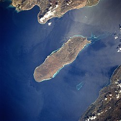
Satellite image of the island. Anse-à-Galets at the top of the island on the right. Picture not northed!
|
||
The port of Anse-à-Galets is located on the northeast side of the island of Île de la Gonâve (formerly Île de la Gonaïve) in the Ouest department of Haiti . It is the capital of the arrondissement (district), which includes the entire island and consists of the two municipalities Anse-à-Galets and Pointe-à-Raquette .
In 2003, 52,662 people lived there on an area of 377 km². The city is located about 50 kilometers west-northwest of the Haitian capital Port-au-Prince .

