Antrim (city)
|
Antrim Aontroim |
|||
|---|---|---|---|
|
|||
| Basic data | |||
| Part of the country | Northern Ireland | ||
| county | Antrim | ||
| District | Antrim and Newtownabbey | ||
| Residents | 23,353 (2011) | ||
| Geographical location | 54 ° 43 ′ N , 6 ° 12 ′ W | ||
| POSTCODE: | BT41 | ||
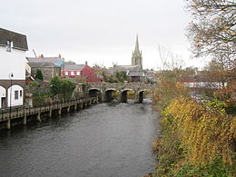
Antrim ( Irish : Aontroim ) is a city in northeast Northern Ireland on the banks of the Six Mile Water ( Abhainn na bhFiodh ) and Lough Neagh and the capital of the traditional county of the same name . It was also the administrative seat of the former district of the same name , which was merged into the Antrim and Newtownabbey district in 2015 . Antrim is now one of the two administrative headquarters of the Antrim and Newtownabbey district. The city is located approximately 35 km northwest of the Northern Irish capital Belfast and had a population of 23,353 at the 2011 Census .
history
At the time of King Edward III. a battle was fought between the Irish and the English near Antrim.
Attractions
- There is a 28 m high intact round tower on the outskirts .
- There is a Norman moth in the grounds of Antrim Castle .
Personalities
- Mark Allen (* 1986), snooker player
- Jordan Brown (born 1987), snooker player
Web links
Commons : Antrim, County Antrim - collection of pictures, videos, and audio files
Individual evidence
- ↑ Antrim (Town) on citypopulation.de, accessed on January 11, 2018

