Apfeldorfhausen
|
Apfeldorfhausen
Apfeldorf municipality
Coordinates: 47 ° 54 ′ 21 ″ N , 10 ° 56 ′ 27 ″ E
|
|
|---|---|
| Height : | 704 m above sea level NHN |
| Residents : | 48 (May 25 1987) |
| Postal code : | 86974 |
| Area code : | 08869 |
|
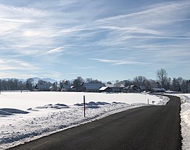
Apfeldorfhausen from the north
|
|
Apfeldorfhausen is a district of the municipality of Apfeldorf in the Upper Bavarian district of Landsberg am Lech .
geography
The village is about a kilometer north of Apfeldorf on the eastern high terrace of the Lech . The Rottbach flows south of the village in a deeply cut valley .
history
Apfeldorfhausen belonged to the Rauhenlechsberg nursing court , three farms are mentioned here in the 15th century.
Architectural monuments
See also: List of architectural monuments in Apfeldorfhausen
- St. Wendelin Chapel , built in the first half of the 18th century
Web links
Commons : Apfeldorfhausen - Collection of images, videos and audio files
- Apfeldorfhausen in the location database of the Bavarian State Library Online . Bavarian State Library
Individual evidence
- ^ Community Apfeldorf: history. Accessed January 30, 2019 .


