Aqsu (Lake Balkhash)
|
Aqsu Ақсу |
||
|
|
||
| Data | ||
| location | Audany Aqsu in the Almaty region ( Kazakhstan ) | |
| River system | Aqsu | |
| source |
Djungarian Alatau 45 ° 1 ′ 11 ″ N , 79 ° 49 ′ 59 ″ E |
|
| muzzle |
Lake Balkhash coordinates: 46 ° 19 '7 " N , 78 ° 10' 43" E 46 ° 19 '7 " N , 78 ° 10' 43" E |
|
| Mouth height |
341 m
|
|
| length | 316 km | |
| Catchment area | 5040 km² | |
| Discharge at the Shansugurow gauge |
MQ |
6 m³ / s |
| Right tributaries | Sarqan | |
| Communities | Matai , Aqsu , Shansugirow | |
|
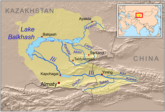
Course of the Aqsu (Aksu) in the catchment area of Lake Balkhash |
||
The Aqsu ( Kazakh Ақсу ; Russian Аксу Aksu ) is a tributary of the Balkhash area Almaty in Kazakhstan .
The Aqsu has its source in the Djungarian Alatau . He leaves the mountains in a northerly direction. Then the river turns to the west and flows through a desert landscape in the lower reaches. Finally the Aqsu turns north and flows into the Balkhash Lake as a trickle. The Aqsu has a length of 316 km. It drains an area of 5040 km². The Aqsu is fed by meltwater from the glaciers in its headwaters. The greatest outflows occur between May and August. The water of the Aqsu is used for irrigation . On the right side the sarqan flows into the aqsu .
Individual evidence
- ↑ a b c Article Aqsu in the Great Soviet Encyclopedia (BSE) , 3rd edition 1969–1978 (Russian)
