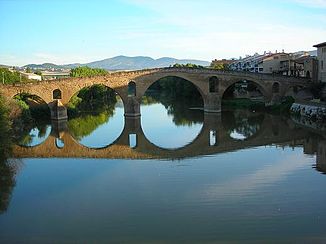
Arga (river)
| Arga | ||
| Data | ||
| location | Navarre , Spain | |
| River system | Ebro | |
| Drain over | Aragón → Ebro → Mediterranean | |
| muzzle |
Aragon Coordinates: 42 ° 17 ′ 47 " N , 1 ° 47 ′ 6" W 42 ° 17 ′ 47 " N , 1 ° 47 ′ 6" W. |
|
| Mouth height |
277 msnm
|
|
| length | 145 km | |
| Catchment area | 2759 km² | |
| Drain |
MQ |
59.76 m³ / s |
| Left tributaries | Río Robo | |
| Right tributaries | Río Ulzama | |
|
Old bridge over the Arga at Puente la Reina |
||
The Arga is a 145 km long right tributary of the Aragón . It rises in the western Pyrenees about 20 km north of Pamplona . From the beginning, it flows almost entirely towards the south. He crosses several cities and towns as well as agricultural areas. It finally flows into the Aragón south of Funes .
Tributaries
Right tributaries:
- Río Ulzama near Villava
- Río Juslapeña near Olza
- Río Araquil near Olza
- Río Salado near Mendigorría
Left tributaries:
- Río Urbi at Huarte
- Río Elorz near Pamplona
- Río Robo at Puente la Reina
Web links
Commons : Arga - collection of images, videos and audio files

