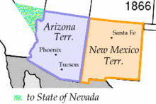
Arizona Territory
The Arizona Territory was a US Congress- administered area in the United States that existed on February 24, 1863. Under the name Arizona , it then joined the Union as the 48th state on February 14, 1912, making it the last state to expand the heartland of the 48 territorially contiguous states of the Union (so-called Lower 48 ).
After the Mexican-American War in 1848, in the Treaty of Guadalupe Hidalgo, an area that included the present-day states of New Mexico and Arizona was ceded by Mexico to the United States as New Mexico Territory .
Around 1860 there were first concrete considerations to divide the New Mexico Territory and split off an Arizona Territory . However, these proposals were based on a division into a northern and a southern territory, instead of a western and an eastern half, as the later states corresponded to. Shortly before the American Civil War in 1861, the area was divided into a northern part, which belonged to the Northern States , and a southern part, which joined the Confederate States of America .
In 1863 Abraham Lincoln declared this area independent. Prescott was chosen as the capital . After the end of the civil war, it was divided into a western half (Arizona Territory) and an eastern half (New Mexico Territory). The Arizona Territory was bordered by New Mexico to the east, Utah to the north, the Mexican state of Sonora to the south, and Nevada and California to the west , from which it was separated by the lower reaches of the Colorado River .
See also
- Historic territories on United States soil
- List of states in the United States (with date of incorporation, sortable by columns)

