
Arnhem Land
Coordinates: 13 ° 0 ′ S , 134 ° 28 ′ E

The Arnhem Land ( English Arnhem Land ) in the Australian Northern Territory is a settlement area of Aboriginal and 97,000 km² somewhat larger than Portugal.
geography
Arnhem Land is on the north coast of the continent, about 200 kilometers east of the city of Darwin . It extends from Port Roper on the Gulf of Carpentaria to the East Alligator River , where it borders Kakadu National Park. The land is administered by the Northern Land Council and is very sparsely populated with just under 20,000 people.
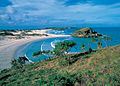
Nanydjaka ( Cape Arnhem )

Alligator River at the Cahills Crossing

Goyder River Crossing on Central Arnhem Road
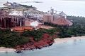
Bauxite refinery on the Gove Peninsula


Culture

The Aborigines in Arnhem Land can look back on a rich cultural history and traditions. They have strong spiritual ties to their land, which is depicted on their rock and tree bark paintings. The musical culture in Arnhemland, especially on the Gove Peninsula , is strongly influenced by the didgeridoo . The musical performances of the band Yothu Yindi from Yirrkala are known worldwide . The didgeridoo maker and musician Djalu Gurruwiwi is also famous .
status
The Australian government recognized the Aborigines as owners of the land in 1976. As Arnhem Land is one of the few areas in Australia where Aborigines traditionally live and are closely connected to their culture, visitors need a special permit from the Aborigines of the Yolngu tribe, which must be applied for up to a year in advance. With the exception of Gunbalanya and the mining town of Nhulunbuy , the Garig Gunak Barlu National Park , the area is closed to free access to tourists. There are now easing of this, for example participation in festivals, for example the Stone Country Festival near Gunbalanya and the Garma Festival near Nhulunby, as well as tourist offers in eastern Arnhem Land, led by Aborigines.
Surname
The country bears the name of the ship Arnhem , named after the city of Arnhem , on which the Dutch navigator Willem Joosten van Colster “discovered” the area in 1623 .
The English explorer and cartographer Matthew Flinders gave the name Arnhem Land .
Web links
Individual evidence
- ^ North-east Arnhem Land Didgeridoos ( Memento of August 14, 2007 in the Internet Archive ), in English, accessed on February 20, 2013
- ↑ tourismustopend.com.au : Oenpelli Open Day , in English, accessed on January 19, 2013
- ↑ govefestival.org.au ( memento of March 5, 2016 in the Internet Archive ): Gove Peninsula Festival 2012 , in English, accessed on February 21, 2013
- ↑ lirrwitourism.com.au : Lirrwi Yolngu Tourism welcomes you to East Arnhem Land , in English, accessed on February 21, 2013
- ↑ ealta.org ( Memento of June 27, 2007 in the Internet Archive ): History of Gove and East Arnhem Land , in English, accessed on February 20, 2013