
Ashcroft, British Columbia
| Ashcroft | |||
|---|---|---|---|
 The historic fire station in Ashcroft |
|||
| Location in British Columbia | |||
|
|||
| State : |
|
||
| Province : | British Columbia | ||
| Regional District : | Thompson-Nicola Regional District | ||
| Coordinates : | 50 ° 44 ′ N , 121 ° 17 ′ W | ||
| Area : | 50.9 km² | ||
| Residents : | 1558 (as of 2016) | ||
| Population density : | 30.6 inhabitants / km² | ||
| Time zone : | Mountain Time ( UTC − 7 ) | ||
| Postal code : | V0K | ||
| Foundation : | 1952 ( incorporated ) | ||
| Mayor : | Jack Jeyes | ||

Ashcroft is a small community in the northern area of the Interior Plateau of British Columbia , Canada . The parish is located about 10 kilometers south of Cache Creek and is part of the Thompson-Nicola Regional District . Ashcroft lies on both banks of the Thompson River .
history
Originally the country was settled by the First Nations , so the history goes back further than the historiography dominated by European immigrants. The Secwepemc lived and still live in the area around present-day Ashcroft . Around 265 of them live in a reserve that extends as far as the community. Therefore there are historical references here and in the surrounding area.
The village's history is strongly tied to the gold rush as the Cariboo Road (also called the Cariboo Wagon Road or Great North Road ) passed through the parish. With the arrival of the railroad, the community was an important stop on the way to the gold fields. Freight and mining deliveries were unloaded from the train here and then made their way north to the gold fields by stagecoach, freight wagon or sleigh. Housing and services quickly increased the influx of people. Ashcroft was full of saddlers , wheelwrights, and blacksmiths . There were numerous horse stables and warehouses. During the period from 1886 to 1920 the village flourished. Before 1920, however, construction of the Pacific Great Eastern Railway to Prince George began and Ashcroft lost its strategic position as a supply center for the north. In addition to this downturn, a fire called The Great Fire destroyed large parts of the village in 1916 . Despite the prosperous growth until then, a post office was not opened in Ashcroft until October 6, 1936.
The village takes its name after a ranch that two brothers founded here. The two brothers named their ranch after Ashcroft, their origin in England.
Demographics
The 2016 census showed a population of 1,558 inhabitants for the municipality, after the 2011 census showed a population of 1,628 inhabitants for the municipality. The population decreased by 4.3% compared to the last census in 2011 and developed against the provincial average, with a population increase of 5.6% in the province. In the census period from 2006 to 2011, the number of inhabitants in the municipality had already decreased by 2.2%, while the provincial average increased by 7.0%.
At the 2016 census, the average age of the residents was 52.0 years, well above the provincial average of 42.3 years. The median age of the residents was determined to be 58.6 years. The median age of all residents in the province in 2016 was 43.0 years. For the 2011 census, a median age of 55.2 years was determined for the residents of the municipality and 41.9 years for the residents of the province.
education
Ashcroft is part of School District # 74 - Gold Trail , which is also located here. There are several schools in the small community, including an elementary school and a secondary school .
politics
The granting of local self-government for the settlement took place only on June 27, 1952 ( incorporated as Village Municipality ). On 31 May 1982, the status of the settlement then changed in a village ( Village ).
Mayor of the parish is Jack Jeyes. Together with four other citizens, he forms the council of the municipality for three years.
economy
The main industry in Ashcroft is agriculture. In addition to retail, the school district is an important employer. The search for and extraction of mineral resources continues to gain in importance.
The average income of Ashcroft employees in 2005 was C $ 21,460, while at the same time the average for the entire province of British Columbia was only C $ 24,867. The income gap between men (C $ 37,616) and women (C $ 16,350) in Ashcroft is greater than the national average. Which can be explained by the fact that women in rural areas are still predominantly housewives and therefore do not earn any income.
traffic
The Trans-Canada Highway ( Highway 1 ) runs about 5 kilometers west of the community . In north-south direction, Highway 97C passes Ashcroft. Also in a north-south direction, two railway lines, one each for the Canadian Pacific Railway and the Canadian National Railway , pass the community. A passenger train, The Canadian , of VIA Rail, stops at Ashcroft station several times a week .
The municipality does not have its own airport, it can only be reached via the airports of the surrounding municipalities.
Picture gallery

Welcome sign

Thompson River in Ashcroft
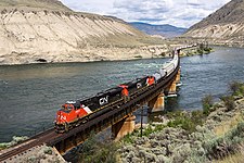
Diesel locomotive ES44AC on the bridge over the Thompson River

.jpg)
,_25.06.2016_-_Flickr_-_miroslav.volek.jpg)
Web links
- Ashcroft ( English, French ) In: The Canadian Encyclopedia .
- City website
- Ashcroft on the tourist site of BritishColumbia.com (English)
Individual evidence
- ^ Ashcroft Community Profile. Census 2016. In: Statistics Canada . January 23, 2017, accessed March 2, 2017 .
- ^ Ashcroft Community Profile. Census 2011. In: Statistics Canada . May 31, 2016, accessed March 2, 2017 .
- ^ Schools. School District # 74 - Gold Trail, accessed January 11, 2013 .
- ^ Origin Notes and History. Ashcroft. GeoBC , accessed January 11, 2013 .
- ^ City website: Council. Retrieved January 19, 2015 .
- ^ Ashcroft Community Facts. (PDF) BCStats , accessed on January 11, 2013 .