
Ashley National Forest
|
Ashley National Forest
IUCN Category VI - Protected Area with Sustainable use of Natural Resources |
||
 View of Kings Peak |
||
| location | Utah & Wyoming , USA | |
| surface | 5,594 km² | |
| Geographical location | 40 ° 20 ′ N , 110 ° 20 ′ W | |
|
||
| Setup date | July 1, 1908 | |
| administration | US Forest Service | |
_relief_location_map.png)
The Ashley National Forest is a 5,601 km² national forest . Most of the federally owned forest is in northeastern Utah (5,212 km²) and a small portion in southwestern Wyoming (389 km²). Like all national forests, it is federally owned and is used intensively for forestry purposes.
Above all, the Flaming Gorge Reservoir and the Uinta Mountains , in which the Kings Peak (4,125 m) is the highest point in Utah, characterize the landscape of the area.
There are various leisure and recreational offers within the area. There are over 1,100 camping options. Fishing and hunting are also allowed and the Flaming Gorge Reservoir is a popular water sports area.
Flora and fauna
Most of them are forests in which the dominant tree species are coastal pines . Trees such as the Engelmann spruce or Douglas fir are also often found here . But also poplars and the striking American quivering aspen grow here. The tree population is therefore rather unusual for the forests in Utah, as otherwise juniper and pinyon pines usually dominate.
The native animal species there include otters , pumas , elk , black bears and ptarmigan .
Protected areas within the forest
With the High Uintas Wilderness there is a total reserve , which is designated as a Wilderness Area . Of this, 60.5% of the total area of the wilderness lies in the Ashley National Forest, while the rest is in the Wasatch-Cache National Forest .
There is also a National Recreation Area around the Flaming Gorge Reservoir, the Flaming Gorge National Recreation Area .
history
The area was first entered by Europeans by Spanish explorers in 1776. However, it was not fully explored and mapped until 1825 on behalf of William Henry Ashley , after his fur hunters had preyed heavily on animal skins in this area the previous year.
He was also the namesake of the establishment of the National Forest on July 1, 1908 by President Theodore Roosevelt . Before that, the area had been partially administered as part of the Uinta Forest Reserve in 1905 .
On October 1, 1968, President Lyndon B. Johnson expanded the area 485 km² by setting up and adding the Flaming Gorge National Recreation Area .
photos

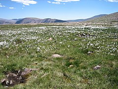
In the forest
View of the High Uintas Wilderness
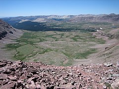
The High Uintas Wilderness as seen from Anderson Pass

View of the Flaming Gorge National Recreation Area


_23-9-2014_12-49-13.JPG)
Web links
- US Forest Service: Ashley National Forest
See also
Individual evidence
- ↑ "Land Areas of the National Forest (English; PDF 2.82 MB), at www.fs.fed.us in January 2012, accessed on June 19, 2017
- ↑ "Information about the Park" , accessed on June 19, 2017
- ^ "Information on tourist activities" , accessed on June 19, 2017
- ↑ [ https://www.fs.fed.us/rm/pubs_series/forest_resources/ashley.pdf "Forest Resources of the Ashley National Forest"] (English; PDF , 940 KB), www.fs.fed.us im December 1997. Retrieved June 19, 2017
- ↑ "Information on the History of the National Forest" , accessed June 19, 2017