
Atakora mountain range
The Atakora Mountain Range (Chaîne de l'Atakora) is a north-east to south-west running mountain range that begins in Ghana north of Accra and then spreads across the border to Togo to Benin and Burkina Faso .
In this low mountain range (the height reaches 600 meters above sea level) comparatively high levels of precipitation are recorded.
The highest mountain in the Atakora chain is Mont Agou ( Mont Baumann , 986 m), which is also Togo's highest mountain. The highest mountains of Benin, the Mont Sokbaro (658 m) and the Mont Tanekas (641 m) are also part of the Atakora chain. The Pendjari , a tributary of the Volta, has its source in the northeastern part of the Atakora chain .
The predominant rocks are sandstones , mica schist and quartzite , from which the mountains are built. On the plateau of the Atakora mountain range, the conditions for agriculture are relatively favorable due to the not too hot but humid climate. The plateau of this low mountain range is very sparsely populated. The arable land is used extensively, i.e. over a very large field-fallow cycle. The farmers, who often live in subsistence farming, sometimes also grow corn , millet , peanuts , yams and cotton for sale .
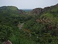
View from the mountain range in north direction on the connecting road from Natitingou to Tanguieta.

View from the mountain range near the entrance of the Pendjari National Park into the plain in north-west direction.
View in direction SW of the Atakora chain (left) and foothills south outside the Pendjari National Park ( Benin ) near the park entrance in Batia .

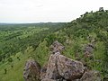
View of the Atakora range from Pendjari National Park ( Benin )

Tree savannahs of the Atakora chain in the Réserve partial de la Kourtiagou .


literature
- Tonakpon Hermane Avohou: Determination of the potentialités pastorales de la Chaine d'Atacora au nord-ouest du Bénin, region de Tanguieta-Batia. Thesis DIA, Université d'Abomey-Calavi 2003, 129 pp.
- Wala Kperkouma: La végétation de la Chaine de l'Atakora au Bénin: diversité floristique, phytosociologie et impact humain. Dissertation Université de Lomé 2004, 140 pp.
- Brice Tente: Research on the facteurs de la diversité floristique des versants du Massif de l'Atacora. Dissertation Université d'Abomey-Calavi 2005, 252 pp.