Natitingou
| Natitingou | ||
|---|---|---|
|
|
||
| Coordinates | 10 ° 18 ' N , 1 ° 23' E | |
| Basic data | ||
| Country | Benin | |
| Atakora | ||
| ISO 3166-2 | BJ-AK | |
| height | 436 m | |
| Residents | 35,000 | |
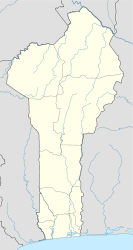
Natitingou is the capital of the Atakora Department in Benin . It has a population of around 35,000 and is located in the northwest of Benin at the foot of the Atakora chain .
Natitingou has a large central market, a museum, two hospitals, a cinema and an airfield . The residential castles called Tata-Somba are known in the region. To the east of the city are the Kota waterfalls , south of the Papatia Botanical Gardens. The RNIE3 road runs through the city and leads north to the border with Burkina Faso .
The city is the seat of the Roman Catholic Diocese of Natitingou .
Town twinning
The towns of Huy in Wallonia (Belgium) and Rillieux-la-Pape in the Rhône department (France) are sister towns to Natitingou.
Web links
Commons : Natitingou - collection of images, videos and audio files


