Athabasca glacier
| Athabasca glacier | ||
|---|---|---|
|
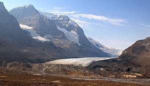
The Athabasca Glacier on Icefields Parkway of view |
||
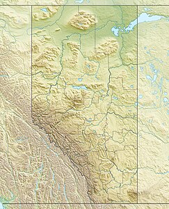
| location | Alberta (Canada) | |
| Mountains | Canadian Rockies | |
| Type | Valley glacier | |
| length | 6 km | |
| surface | 6 km² | |
| Altitude range | 2700 m - 2000 m | |
| width | Max. 1 km | |
| Ice thickness | Max. 300 m | |
| Coordinates | 52 ° 11 ′ 27 ″ N , 117 ° 15 ′ 19 ″ W | |
|
|
||
| drainage | Sunwapta River | |
The Athabasca Glacier (English Athabasca Glacier ) is one of the six main tongues of the Columbia Ice Field in the Canadian Rockies . The glacier flows northeast from the ice field to the Icefields Parkway . It is flanked on one side by the 3550 m high Snow Dome and the 3450 m high Mount Andromeda . The meltwater flows over the Sunwapta Lake into the Sunwapta River .
Due to the climatic warming , the glacier has retreated 1.5 km in the last 125 years and lost more than half of its volume.
Because of its proximity to the Icefields Parkway, it is one of the most visited glaciers in North America. The Icefield Center, located on the Icefields Parkway, offers guided tours in summer with special buses (the Snowcoaches ) to the Athabasca Glacier.
6 km away is the Glacier Skywalk ; an accessible platform in the shape of a round arch with a glass floor approx. 280 m above the Sunwapta valley. The builder, Brewster Travel Canada, opened the new attraction on Icefields Parkway in May 2014.
media
Drive over the glacier
Web links
- Columbia Icefield Area and the Athabasca Glacier (English)
- earthsciencescanada.com: Athabasca Glacier and the Columbia Icefield (2011) (PDF, 1.9 MB)
Individual evidence
- ↑ Brewster Travel Canada: Official website of the project company ( Memento of the original from February 14, 2012 in the Internet Archive ) Info: The archive link was inserted automatically and has not yet been checked. Please check the original and archive link according to the instructions and then remove this notice.


