Auerbach (Wartenberg)
|
Englmannsberg
Wartenberg market
Coordinates: 48 ° 23 '50 " N , 12 ° 0' 48" E
|
||
|---|---|---|
| Height : | 490 m above sea level NHN | |
| Residents : | 66 (2012) | |
| Incorporation : | January 1, 1972 | |
| Postal code : | 85456 | |
| Area code : | 08762 | |
|
Location of Englmannsberg in Bavaria |
||
|
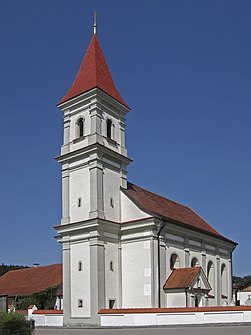
Filial church of St. Bartholomew
|
||
Auerbach is a district of the market Wartenberg (Upper Bavaria) in the district of Erding in Bavaria .
geography
Auerbach is located 2 kilometers southeast of Wartenberg on the Auerbach that gives it its name.
history
Around Auerbach there are large ring walls from the early Middle Ages.
The Catholic branch church of St. Bartholomew in Auerbach is a uniform baroque hall building with a retracted semicircular choir, built by Anton Kogler around 1720.
On January 1, 1972, the municipality of Auerbach , founded with the Bavarian municipal edict of 1818, was incorporated into Wartenberg.
Individual evidence
- ^ Müller's Large German Local Book 2012. De Gruyter Verlag, 2012, p. 73.
- ↑ List of monuments for Wartenberg (PDF) at the Bavarian State Office for Monument Preservation
- ^ Wilhelm Volkert (ed.): Handbook of Bavarian offices, communities and courts 1799–1980 . CH Beck, Munich 1983, ISBN 3-406-09669-7 , p. 458 .

