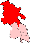
Aylesbury Vale
| Aylesbury Vale District | |
|---|---|
 Location in Buckinghamshire |
|
| status | District |
| region | South East England |
| Administration County | Buckinghamshire |
| Administrative headquarters | Aylesbury |
| surface | 902.75 km² |
| Residents | 174,100 |
| ONS code | 11UB |
Aylesbury Vale was a District in the county of Buckinghamshire in England . It existed from 1974 to 2020. It was named after the valley in the Chiltern Hills in which the then administrative seat of Aylesbury is located. Other important places were Buckingham and Winslow .
The district was formed on April 1, 1974 and was created from the merger of the boroughs Aylesbury and Buckingham, the Rural Districts Aylesbury, Buckingham and Wing and part of the Rural District Winslow. On April 1, 2020, the district was dissolved and merged with the three other districts of the county to form the Unitary Authority Buckinghamshire .
Individual evidence
Coordinates: 51 ° 53 ′ 27.7 " N , 0 ° 54 ′ 43.3" W.