Leg
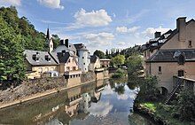
A stone pedestrian bridge in the city of Luxembourg ( lux . : Stad Lëtzebuerg ) is called Béinchen ( German : little leg ) and is located north of the city, between the gate tower Siechentor (lux .: Sichepaart ; French : Porte des Bons-Malades ) and the gate tower Eichertor (lux .: Eecherpaart ; French: Porte d'Eich ) and crosses the Alzette . Originally it was a closing and connecting wall with a wooden battlement in the middle over a length of about 100 meters and with three fields. At the time of the fortress of Luxembourg before 1876, this closing and connecting wall was militarily fortified and provided with loopholes and part of the outer fortress wall. The original wall was built as a locking bolt in Pfaffenthal (lux .: Pafendall ) in 1684 according to the plans of the French fortress builder Sébastien Le Prestre de Vauban over the Alzette.
After the demolition of the fortress Luxembourg after 1867 this compound wall was a public footbridge rebuilt.
Surname
The bridge is named legs of the three bridge arch (lux .: Bou or Boubréck as defined arc or arch bridge ). The vernacular then called the Vauban Bridge Béinchen .
Appearance and function
The closing and connecting wall or defensive wall consisted of two approximately 3 meter high walls, one upstream and one downstream. In the middle a wooden catwalk. The walls had loopholes. If necessary, an oak grating was lowered near the arches of the bridge to Alzette to prevent anyone from entering the city or leaving it across the river.
After the fortress of Luxembourg was razed in 1867 , the walls were lowered to about 1 meter.
On the initiative of the Service des sites et monuments nationaux , the Béinchen , the trenches, the gate towers (Vauban Towers) and the Ravelin in front of the Eichertor were restored in the 1990s . Since then, it has also been possible to get to know these structures on a guided tour.
UNESCO World Heritage Site
Since 1994, the stand legs and the Vauban towers along with the other remains of the former fortress of Luxembourg on the UNESCO list of world cultural heritage .
At the Béinchen
At the Béinchen is the name of a quarter next to the Béinchen on the left side of the Alzette. On May 30, 1976, an entire block of houses was seriously damaged by the deflagration of gasoline gases from the sewer system . Three people died in this accident. The quarter was rebuilt around 1986.
literature
- Cyrille Savin: L'héritage culturel Vauban à Luxembourg. Guide historique. Itinéraire Vauban , Éditions Saint-Paul, Lëtzebuerg 2005, Service des sites et monuments nationaux, ISBN 2-87963-513-6 .
- Fernand Théato: Beim Béinchen , Lëtzebuerg 2007, Éditions Sang & Klang Pafendall, Dréckerei Victor Bück.
Web links
- Website of the interest group Pafendall-Sichenhaff
- Tours Vauban: Les portes d'Eich et des Bons Malades et le mur Vauban. , Website: ssmn.public.lu.
Individual evidence
- ↑ See also: Treaty of London 1867 .
- ↑ Fernand Théato, 2007. Beim Béinchen , p. 108.
- ↑ Vauban circular route on the trail of the fortress builder. From the Bockfelsen to the Kirchbergg , website: www.luxembourg-city.com, p. 5.
- ↑ See also the information board at the Ravelin.
- ↑ The tall, slender chimney on the river bank near the Eichertor is not part of the fortification, but rather a remnant of a pumping station (1876) that pumped spring water from the valley floor into the upper town.
Coordinates: 49 ° 37 ′ 0.1 ″ N , 6 ° 7 ′ 55.3 ″ E


