
Böhmerstrasse (Trier)
| Böhmerstrasse | |
|---|---|
|
|
|
| Basic data | |
| place | trier |
| District | center |
| Connecting roads | Justice Street |
| Cross streets | In the Olk , Zuckerbergstrasse, Metzelstrasse |
| Places | Nikolaus-Koch-Platz , Irminenfreihof |
The Böhmerstraße is a street in Trier in the district center . It runs from Nikolaus-Koch-Platz to Irminenfreihof in close proximity to the banks of the Moselle. It is one of the few important business streets in the west of the old town of Trier.
history
A settlement "Beheim" was first documented in 1115. However, the origin of the name “Beheim” has not been clearly established. There are two possible explanations:
- The name of this settlement is probably derived from a Frankish single settlement "Beheim", which was built on the soil of the destroyed Roman city.
- But it could also be a former slavery terminal with slaves from Bohemia or (more likely) a settlement founded by Slavic slaves that were bought by the Trier church.
The settlement was probably located between Böhmerstrasse and Dietrichstrasse . The former desert is now completely built over.
Cultural monuments
There are (at least) three cultural monuments from the 19th century in the street . Particularly noteworthy among the buildings on the street is the St. Elisabeth monastery:
St. Elisabeth Monastery
The monastery “St. Elisabeth ”was built on April 22, 1864 by the“ Franciscan Sisters of Penance and Christian Love ”from Nonnenwerth in Böhmerstrasse. A previous building stood ten years earlier on Dominikanerstrasse. Because of its location, it was popularly called "Bohemian Monastery". Both during the First World War and the Second World War , the monastery was destroyed and subsequently rebuilt. Today the building is used as a youth hostel, old people's home, housekeeping training center, parish pastoral care and as a kindergarten with the help of the Franciscan nuns in the "Bohemian Monastery".

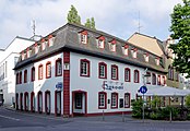
Böhmerstrasse 6
Böhmerstrasse 10

Böhmerstrasse 11
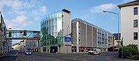
City parking garage at the corner of Böhmerstrasse - Zuckerbergstrasse


literature
- Patrick Ostermann (arrangement): City of Trier. Old town. (= Cultural monuments in Rhineland-Palatinate. Monument topography Federal Republic of Germany . Volume 17.1 ). Wernersche Verlagsgesellschaft, Worms 2001, ISBN 3-88462-171-8 .
- Ulrike Weber (arrangement): City of Trier. City expansion and districts. (= Cultural monuments in Rhineland-Palatinate. Monument topography Federal Republic of Germany . Volume 17.2 ). Wernersche Verlagsgesellschaft, Worms 2009, ISBN 978-3-88462-275-9 .
- General Directorate for Cultural Heritage Rhineland-Palatinate (publisher): Informational directory of cultural monuments of the district-free city of Trier . Koblenz 2010 ( gdke-rlp.de [PDF; 1,2 MB ; accessed on September 7, 2015]).
- Emil Zenz: Street names of the city of Trier: their meaning and their meaning . Ed .: Culture Office of the City of Trier. 5th edition. Trier 2006, DNB 455807825 (first edition: 1961).
Individual evidence
- ^ Emil Zenz: Street names of the city of Trier: their sense and their meaning . Ed .: Culture Office of the City of Trier. 5th edition. Trier 2006, DNB 455807825 (first edition: 1961).
- ↑ a b Walter Janssen: Studies on the desert question in the Franconian old settlements between the Rhine, Moselle and Eifelnordrand . Rheinland-Verlag, Cologne 1975, DNB 750284536 (2 volumes, text and catalog).
- ↑ Gottfried Kentenich : Trier, its history and art treasures. Short illustrated guide . 2nd improved edition. J. Lintz, Trier 1933, DNB 574285873 .
- ↑ Patrick Ostermann (arrangement): City of Trier. Old town. (= Cultural monuments in Rhineland-Palatinate. Monument topography Federal Republic of Germany . Volume 17.1 ). Wernersche Verlagsgesellschaft, Worms 2001, ISBN 3-88462-171-8 .
- ↑ St. Elisabeth nursing home for the elderly, Trier. (No longer available online.) Angela von Cordier Foundation, archived from the original on April 13, 2014 ; accessed on September 7, 2015 .
- ↑ Entry on St. Elisabeth Monastery in the database of cultural assets in the Trier region .
Coordinates: 49 ° 45 ′ 25.9 " N , 6 ° 38 ′ 10.4" E