
Bühl (Pfedelbach)
|
Buhl
municipality Pfedelbach
Coordinates: 49 ° 8 ′ 12 ″ N , 9 ° 34 ′ 13 ″ E
|
|
|---|---|
| Height : | 276 m above sea level NN |
| Residents : | 95 (June 1, 2010) |
| Incorporation : | 1st September 1971 |
| Postal code : | 74629 |
| Area code : | 07949 |
 Location of Bühl in Pfedelbach
|
|
Bühl was a part of Untersteinbach for a long time and has belonged to the Pfedelbach community in the Hohenlohe district since January 1, 1972 .

Geographical location
Bühl is located in the Ohrntal , south of Untersteinbach on the L 1049 road. On the L 1049, the Ohrn forms the border between Bühl and Untersteinbach.
history
The place appears for the first time as Zum Bühel in a tax list from 1410, the valid book of the Grafschaft Hohenlohe. The town's mill is also listed there. At that time it was called Renkenmühle, later the ancestors of the American Gulf War general Norman Schwarzkopf, Jr. lived here, today it is owned by the Barth family. The water-powered grinder still works. On the Homann map of the County of Hohenlohe from 1748, the village is named Zum Buhl .
Sports
- The sports hall in the Steinbacher Tal, inaugurated in 2010, is located in the Bühl.
- Kneipp facility

The Barth'sche Mühle in Bühl. Residence of General Schwarzkopf's ancestors
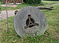
Old millstone at the Barth'schen Mühle

Boulder with a plaque commemorating the 600th anniversary

The landmark between Bühl and Ohnholz


literature
- Gerhard Taddey (Red.): Pfedelbach 1037–1987. From past and present (= research from Württembergisch-Franken. Vol. 30). Published by the Pfedelbach community. Thorbecke et al., Sigmaringen et al. 1987, ISBN 3-921429-30-7 .
Individual evidence
- ↑ Peter Hohl: Small living space celebrates a big anniversary . In: Hohenloher Zeitung . July 2, 2010 ( from Stimme.de [accessed July 4, 2010]).