
Bünzau
|
Bünzau Bünzer Au, Bünzener Au |
||
 Bünzau at the bridge in Aukrug-Innien |
||
| Data | ||
| Water code | DE : 59764 | |
| location | Schleswig-Holstein , Germany | |
| River system | Elbe | |
| Drain over | Stör → Elbe → North Sea | |
| origin | Confluence of Buckener Au and Fuhlenau north of Innien 54 ° 5 ′ 59 ″ N , 9 ° 46 ′ 59 ″ E |
|
| muzzle | In the Stör coordinates: 54 ° 1 '46 " N , 9 ° 48' 55" E 54 ° 1 '46 " N , 9 ° 48' 55" E
|
|
| length | 15.7 km | |
| Discharge at the Sarlhusen A Eo gauge : 207 km² Location: 600 m above the mouth |
NNQ (May 24, 1974) MNQ 1984–2014 MQ 1984–2014 Mq 1984–2014 MHQ 1984–2014 HHQ (January 6, 1988) |
160 l / s 713 l / s 2.68 m³ / s 12.9 l / (s km²) 15.3 m³ / s 24.1 m³ / s |
| Left tributaries | Höllenau , Bredenbek , Wischbek | |
| Right tributaries | Burbek , Kapellenbach , Sellbek , Tönsbek , Glasbek | |
The Bünzau is a right (northern) tributary of the Stör in Schleswig-Holstein .
The river has a length of 15.7 km, the difference in altitude is 10 meters. It arises north of Innien from the confluence of Buckener Au and Fuhlenau , the Buckener Au being the longer source river. The Bünzau is a sand-shaped lowland stream . Important tributaries are Höllenau and Bredenbek .
The Bünzau was navigable for the boats common at the time until around 1870 . With this, wood was transported from Aukrug south to the Stör and on to the Elbe from the Bünzer port .

River system of the Bünzau (schematic)

Bünzau in summer ...
... and in autumn after heavy rain

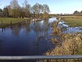
Bünzau valley at "flood"

The Bünzau in the Aukrug-Bünzen district


Individual evidence
- ^ German Hydrological Yearbook Elbe Region, Part III 2014. (PDF) ISSN 0949-3654. Free and Hanseatic City of Hamburg, Hamburg Port Authority, p. 162 , accessed on October 4, 2017 (German, at: dgj.de).
- ↑ Federal Environment Agency - Type 14 sand-shaped lowland streams