Glasbek
| Glasbek | ||
|
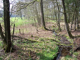
Upper course of the Glasbek in spring 2012 |
||
| Data | ||
| location | Schleswig-Holstein , Germany | |
| River system | Elbe | |
| Drain over | Bünzau → Stör → Elbe → North Sea | |
| source | south of Aukrug -Bargfeld 54 ° 3 '6 " N , 9 ° 46' 34" O |
|
| muzzle | at Aukrug in the Bünzau coordinates: 54 ° 2 '45 " N , 9 ° 49' 8" E 54 ° 2 '45 " N , 9 ° 49' 8" E
|
|
| length | 2.9 km | |
The Glasbek (in old maps also Glasebek or Glosebek ) is a right tributary of the Bünzau in Schleswig-Holstein . The brook has a length of about 3 km and forms the border between the Rendsburg-Eckernförde and Steinburg districts . It rises southeast of the Tönsheider forest between Aukrug and Sarlhusen and flows south of Aukrug-Bargfeld into the Bünzau.
The approx. 1 kilometer long upper course in the forest has been preserved close to nature, while the lower course has largely run in pipes since the land consolidation and was only recognizable as a moat in some places . In spring 2012, the construction work for the renaturation of the lower reaches began.
Individual evidence
- ^ Georg Reimer : The watermills in the office of Rendsburg , local history yearbook 1955 for the district of Rendsburg, pp. 84–129, Verlag Heinrich Möller
Web links
Commons : Glasbek - collection of pictures, videos and audio files

