
Bütgenbach dam
| Bütgenbacher See | |||||||||
|---|---|---|---|---|---|---|---|---|---|
 |
|||||||||
|
|||||||||
|
|||||||||
| Coordinates | 50 ° 25 '40 " N , 6 ° 13' 25" E | ||||||||
| Data on the structure | |||||||||
| Construction time: | 1929–1932, by Ing. Boldo | ||||||||
| Height of the barrier structure : | 23 m | ||||||||
| Power plant output: | 2,200,000 kWh / year | ||||||||
| Data on the reservoir | |||||||||
| Altitude (at congestion destination ) | 550 m OP | ||||||||
| Water surface | 1.25 km² | ||||||||
| Total storage space : | 10 858 900 m³ | ||||||||
| Particularities: |
Details about the dam in the text |
||||||||
 |
|||||||||

The Bütgenbach dam with the Bütgenbacher See was built around 1932. Its main task is to regulate its main tributary, the Warche , which rises near the Belgian-German border near Losheim. The Warche was known as one of the most unpredictable rivers in Belgium . To regulate the Warche, but also to ensure that the industries in Malmedy (tanneries and paper industry) always had enough water, the Bütgenbach dam was built together with the downstream dam in Robertville in the municipality of Weismes, which was built in 1929 . The operator of the dam is the energy distribution company Engie Electrabel .
The location
The dam is located in the German-speaking Community (DG) in Belgium in the area of the municipalities of Büllingen and Bütgenbach , between the villages of Bütgenbach, Berg and Wirtzfeld . On the side of the village of Bütgenbach, directly in front of the entrance to the barrier wall, you can still see the remains of the former castle of Bütgenbach.
The construction
The dam, a pillar dam, consists of 11 arches with a span of 12 meters each with a horizontal incline of 40 degrees. The content of the barrier wall is 28,000 cubic meters of concrete. At the ends of the barrier wall there are two concrete walls for anchoring in the rock. When building the wall, however, it was found that the rock on the Berger side was not massive, but only consisted of slate, so reinforcement was necessary to fasten the wall on this side, which you can see when crossing the wall on the (former) Can still see the road quite well. For sealing, the wall is covered with a cement mortar and a layer of asphalt.
When completely filled, the lake has a volume of 11 million cubic meters over an area of 125 hectares. A drainage pipe at the lower end of the wall is used for draining. There is also an overflow on the Bütgenbach side.
Electricity production: The electrical center at the foot of the system is equipped with a single alternator of 2,300 kVA, which generates a voltage of 6 kV at a speed of 300 revolutions per minute. The center was put into operation in 1933 and, depending on the amount of water, produces between 875,000 kWh and 2,900,000 kWh annually.
Tourist use
A small campsite on the edge of the Bütgenbacher See had been in existence since the 1950s. In the 1970s, the Bütgenbach advertising committee expanded the campsite considerably. At the same time, the Worriken sports and leisure center was built. There are also bathing opportunities on the lake side below the Berg district. The 10 km circular route around the lake was set up for hikers . The Warche - Tour hiking trail is signposted between the Bütgenbacher dam and the dam in Robertville . The RAVeL L45a runs along the lake on the route of the former Weywertz-Jünkerath railway line .

Bütgenbacher See dam

Evening at the lake
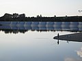
Anglers in front of the dam

The Warche Tour to Robertville
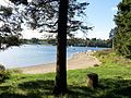
Bütgenbach on the Warche reservoir


