
Backenberger See
| Backenberger See | ||
|---|---|---|

|
||
| View from the north flank of the lake, February 2015 | ||
| Geographical location | Between Güntersen and Löwenhagen , Adelebsen , Göttingen district , Lower Saxony | |
| Places on the shore | Güntersen | |
| Location close to the shore | Goettingen | |
| Data | ||
| Coordinates | 51 ° 32 '2.8 " N , 9 ° 43' 34" E | |
|
||
| length | 250 m | |
| width | 30 m | |
|
particularities |
By basalt mining emerged |
|

The Backenberger See (also Backenbergsee, Kratersee Güntersen, Kratersee im Backenberg) is a lake created by basalt mining near Güntersen between Dransfeld and Adelebsen in the district of Göttingen , Lower Saxony .
Although the lake is often referred to as a crater lake, it is not a volcanic crater filled with water . The 385 m high Backenberg near Güntersen is an extinct volcano around 14 million years ago in the Tertiary ( Miocene ) . The basalt has been degraded as a valuable resource 1927-1972. A 4 km long cable car transported the rock to a loading station of the Lower Saxony basalt works in Adelebsen. The lake has filled the basalt pit that was created during mining.
You can also swim in an easily accessible place in the lake.
Picture gallery
East bank seen from the north flank, September 2013

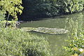
Water lilies on the east bank, in the background the northwest bank, September 2013

View from the west, February 2015


See also
Web links
- Wiki-Göttingen: Backenberger See (accessed September 19, 2014)
- Galerie Göttinger Land: Basalt quarry Backenberg (accessed September 19, 2014)
Individual evidence
- ↑ Wolfgang Dahms: going for a walk, hiking, stopping off - Volume II. 240 pages, Verlag Mecke Druck, Duderstadt. ISBN 978-3-86944-069-9