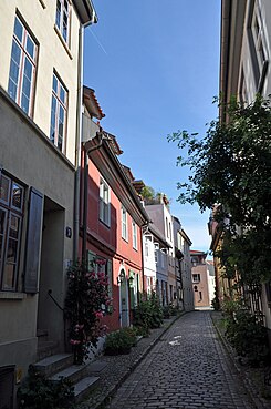
Badstüberstrasse (Stralsund)
| Badstüberstrasse | |
|---|---|
| Street in Stralsund | |
| View of Badstüberstrasse in Stralsund, from Langenstrasse (2013) | |
| Basic data | |
| place | Stralsund |
| District | center |
| Created | 13th Century |
| Connecting roads | Frankenwall (SW) |
| Cross streets |
Langenstrasse (north area), Frankenstrasse (middle), Frankenwall (southwest) |
| Buildings | 4 architectural monuments |
| use | |
| User groups | Pedestrian traffic , bicycle traffic , car traffic |
| Technical specifications | |
| Street length | around 100 meters |
The Badstüberstrasse in Stralsund connects the Heilgeiststrasse near the Wasserstrasse with the Frankenwall . The Papestraße goes on the Badstüberstraße; the Long Road and the Frankenstraße cross the Badstüberstraße. It belongs to the core area of the UNESCO World Heritage with the title Historic Old Towns Stralsund and Wismar .
history
The street was first mentioned in a document at the end of the 13th century; in the city book of 1288 there is talk of the street "between the Langen- and Heilgeisttor". Its name goes back to the Badstüber operators of bathing rooms , public bathing facilities.
Originally only the section between Heilgeiststrasse and Langenstrasse was called Badstüberstrasse, which is attributed to the bathing rooms of the Heilgeist Hospital . The section between Langenstrasse and Frankenstrasse was initially called Gerwenhagen after a resident Gerwin. From the 15th century, this section was called Pickhagen , as pitch ( Pick ) was stored here for the nearby shipyards . The section between Frankenstrasse and Frankenwall was called the Frankenmauer after the part of the Stralsund city fortifications standing here . In 1869 the sections between Fährstraße and Frankenwall were merged to form Mauerstraße , and in 1920 this part of Mauerstraße was renamed Badstüberstraße.
Today's house numbers were assigned in the 19th century. The bombing raid on Stralsund on October 6, 1944 destroyed some of the 25 buildings on Badstüberstrasse.
Architectural monuments
In the street there are four buildings under monument protection , see also the list of architectural monuments in Stralsund . These are the buildings with the house numbers 13 , 15 , 16 , and 22 . In some houses remains of the demolished city wall have been preserved.
literature
- Andreas Neumerkel, Jörg Matuschat: From the butt notch to Zipollenhagen. Stralsund streets and their history. 3. Edition. Kruse printing and publishing house, Stralsund 2007, ISBN 978-3-941444-01-0 .
- Friederike Thomas, Dietmar Volksdorf: The old town island Stralsund - Illustrated list of monuments. The architectural monuments of the old town in text and images. Edited by the building authority of the Hanseatic city of Stralsund. Self-published, Stralsund 1999, DNB 987697757 .
Web links
Individual evidence
- ↑ Roughly measure the length of the road with the tool from Google Earth
- ↑ Definition of terms Badstüber on www.enzyklo.de; accessed on November 1, 2019.
- ↑ Andreas Neumerkel, Jörg Matuschat: From the butt notch to Zipollenhagen. Stralsund streets and their history. 3. Edition. Printing and publishing house Kruse, Stralsund 2007, ISBN 978-3-941444-01-0 , p. 14.
- ↑ Friederike Thomas, Dietmar Volksdorf: The old town island Stralsund - Illustrated list of monuments. The architectural monuments of the old town in text and images. Edited by the building authority of the Hanseatic city of Stralsund. Self-published, Stralsund 1999, DNB 987697757 , pp. 18-19.
Coordinates: 54 ° 18 '47.8 " N , 13 ° 5' 44" E
