
Baggersee (Regensburg)
|
Baggersee Baggerweiher, Westbadweiher |
||
|---|---|---|
.jpg)
|
||
| Quarry pond | ||
| Geographical location | Westheim subdistrict in the west quarter of the city of Regensburg , Upper Palatinate , Bavaria , Germany | |
| Data | ||
| Coordinates | 49 ° 1 '36 " N , 12 ° 3' 18" E | |
|
||
| Altitude above sea level | 330 m above sea level NN | |
| surface | 12 ha | |
| length | 713 m | |
| width | 226 m | |

The Regensburg Baggersee , also called Baggerweiher or Westbadweiher , is a groundwater lake and the largest lake in the urban area of Regensburg . It is located in the area of the former airfield near the Westheimsiedlung in the western quarter of Regensburg near the northernmost point of the Danube.
history
Small gravel mining areas in which groundwater collected had existed east of the nearby Westheimsiedlung since the 1930s . After expansions were made difficult in the post-war period due to complicated property conditions, gravel extraction was made possible west of the settlement. The former gravel pits east of the Westheimsiedlung were filled in in the following decades and subsequently built on.
In the area of the former airfield near the former Messerschmitt works, on the other hand, large areas of gravel could be excavated immediately south of the Danube in the early 1950s, at that time by the Almer gravel dredger. At that time, it was planned to expand the airfield to the east south of the gravel mining area, after the occupying forces opened the way to civil aviation from 1955. After the project ultimately failed and the airfield was shut down in 1961, today's 65-hectare West Park, also known as the Danube Park, was able to be built after the gravel mining had been completed.
After the removal of the material, the gravel quarrying left behind today's groundwater lake, also known as the “excavator pond”. Because of the directly adjacent Westbad , it is also called "Westbadweiher". Since the damming of the Danube in 1977, a pumping station has ensured a constant water level in the 12-hectare excavator pond.
The Baggersee is the largest lake in the urban area and was used for swimming by the Regensburg citizens in the 1980s. After the water quality deteriorated massively as a result, the riparian zones were planted to give flora and fauna a place within the urban area. The lake now has good water quality again and is home to numerous water bird species.
gallery

Baggersee Regensburg with Westbad in the background
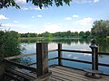
View over the "Baggerweiher" from the viewing platform in the north

South bank of the "Baggerweiher"

View from the west over the quarry pond with Winzerer Höhen in the background


literature
- Peter Schmoll: The Messerschmitt Works in World War II. The aircraft production of Messerschmitt GmbH Regensburg from 1938 to 1945. MZ-Verlag, Regensburg 2004, ISBN 3-931904-38-5
Web links
Individual evidence
- ↑ 50 years Westheimsiedlung 1933-1983 , (1983)
- ↑ Egolf Biscan: Excerpt from the "Aviation History Regensburg" . Archived from the original on July 30, 2018. Info: The archive link was inserted automatically and has not yet been checked. Please check the original and archive link according to the instructions and then remove this notice. Retrieved July 30, 2018.
- ^ Information board Donaupark City of Regensburg
- ^ Daniel Steffen: Newspaper clipping Mittelbayerische Zeitung - northernmost point of the Danube . In: Mittelbayerische.de . September 9, 2016. Retrieved May 19, 2018.
- ↑ Newspaper clipping "Swimming, cycling and strolling on the northernmost bend of the Danube" . Excerpt from the municipal article "Bei uns" of the city of Regensburg. September 2017