Entzheim-Aéroport station
| Entzheim-Aéroport | |
|---|---|
|
View from the overpass
|
|
| Data | |
| Design | Through station |
| Platform tracks | 2 |
| IBNR | 8701099 |
| Price range | B (more than 100,000 travelers per year) |
| opening | 2008 |
| location | |
| City / municipality | Entzheim |
| Department | Bas-Rhin department |
| region | Grand Est |
| Country | France |
| Coordinates | 48 ° 32 '49 " N , 7 ° 37' 41" E |
| Height ( SO ) | 153 m |
| Railway lines | |
| List of train stations in France | |
The Entzheim-Aéroport station is the Airport Station of Strasbourg airport and is located a few meters from this distance on the railway line Strasbourg-Saint-Die .
history
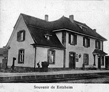
The train station at its present location since 2008, replaced the original about 400 meters further southwest to ( 48 ° 32 '44.2 " N , 7 ° 37' 20.3" O ) and 1864 of the Chemin de fer de l'Est opened Railway station. The station building there was demolished in the course of the relocation.
traffic
The journey to Strasbourg train station in downtown Strasbourg takes between 7 and 12 minutes (with or without stops) and costs EUR 2.70 (as of January 2018). The TER Alsace trains run several times an hour.
Web links
Commons : Entzheim-Aéroport station - collection of images, videos and audio files
- Station information on SNCF TER Grand Est (French)
- Information about the shuttle train on the Strasbourg airport site
Individual evidence
- ^ Pierre Friedrichs: Le chemin de fer à Entzheim. In: entzheim.fr. Entzheim municipality , accessed on January 4, 2019 (French, German Die Eisenbahn in Entzheim ).

