Revigny – Saint-Dizier railway line
| Revigny – Saint-Dizier | |||||||||||||||||||||||||||||||||||||||||||||||||||||||||||||||||||||||||
|---|---|---|---|---|---|---|---|---|---|---|---|---|---|---|---|---|---|---|---|---|---|---|---|---|---|---|---|---|---|---|---|---|---|---|---|---|---|---|---|---|---|---|---|---|---|---|---|---|---|---|---|---|---|---|---|---|---|---|---|---|---|---|---|---|---|---|---|---|---|---|---|---|---|
|
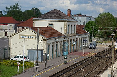
Revigny station , 2010
| |||||||||||||||||||||||||||||||||||||||||||||||||||||||||||||||||||||||||
| Route number (SNCF) : | 019 000 | ||||||||||||||||||||||||||||||||||||||||||||||||||||||||||||||||||||||||
| Route length: | 28 km | ||||||||||||||||||||||||||||||||||||||||||||||||||||||||||||||||||||||||
| Gauge : | 1435 mm ( standard gauge ) | ||||||||||||||||||||||||||||||||||||||||||||||||||||||||||||||||||||||||
| Maximum slope : | 7 ‰ | ||||||||||||||||||||||||||||||||||||||||||||||||||||||||||||||||||||||||
| Dual track : | formerly yes | ||||||||||||||||||||||||||||||||||||||||||||||||||||||||||||||||||||||||
|
|||||||||||||||||||||||||||||||||||||||||||||||||||||||||||||||||||||||||
The Revigny – Saint-Dizier railway is a former 28 km long strategic railway line in France . It connected in St. Dizier on the double-track, south-facing railway line Blesme-Haussignémont – Chaumont with Revigny on the Paris – Strasbourg line . From this northern point of Revigny there was the connecting line Amagne-Lucquy-Revigny via Sainte-Menehould to Armagne-Lucquy , which still connects today to the double-track connection Reims - Charleville . This last-mentioned route led right through the middle of the battlefield of the First World War about 35 km west of Verdun .
history
This railway line is part of the Freycinet plan with the N ° 18 , with which 181 lines were realized in 1879 under the aftermath of the Franco-Prussian War . In Revigny in particular, extensive overpass structures were built to enable cross-free traffic. Except for the crossing of the Canal de la Marne au Rhin, built in 1853, and the nearly 450-meter-long tunnel de Baudonvilliers , there were no topographical obstacles worth mentioning. The slope of 7 ‰ is correspondingly low. The apex is about one kilometer north of the tunnel portal facing Revigny. All stops on the way were stations with several switches, although the eponymous towns hardly needed a train station. This route was part of SNCF route 26 7 .
In the hamlet of Robert-Espagne there was a connection to Haironville , which is a good seven kilometers away as the crow flies. This route was originally laid out in meter gauge for the iron forge enclosed by the forest there, but was later converted to standard gauge and connected to the network of the Chemin de fer de l'Est (CE). In 1914 there were three round trips, all of which led to Revigny.
The siding to the north of the tunnel de Baudonvilliers is also related to this. The forest area Fôret Domaniale de Trois-Fontaines was intensively cultivated and served as raw material for this paper mill. From 1951 to 1966 the US troops were stationed here with their largest ammunition depot in France.
The railway company CE was the concessionaire for the construction and operation of the line, which went into operation on March 15, 1885 and was closed for passenger traffic on May 5, 1938. The deedication took place in 1972 (approx. 14.3 km) and 1976 (approx. 8.7 km). Almost four kilometers are still drivable from Revigny to serve an ArcelorMittal plant .
Individual evidence
- ↑ N ° 8168. Loi qui classe 181 lignes de Chemins de fer dans le réseau des Chemins de fer d'inteérêt general. In: Bulletin des lois de la République française , Paris 1879, Imprimerie nationale
- ↑ Loi qui class 181 lignes de Chemins de fer dans le réseau des Chemins de fer d'intérêt general les lignes dont la désignation. Collection complète des lois, décrets, ordonnances, réglements, et avis du Conseil d'Etat. Jean-Baptiste Duvergier, 17th-18th centuries July 1879
- ↑ Tunnel de Baudonvilliers on Inventaire the tunnel Ferroviaires de France . Data sheet.
- ↑ SNCF Region de l'Est. Carnet de profils et schémas, 1962, sheet 170
- ↑ Société des Forges d'Haironville on http://www.passion-metrique.net/forums/viewtopic.php?f=2&t=4256&start=45 (French)
- ^ Trois Fontaines Class V Area . Le plan de depot , at: http://www.passion-metrique.net/forums/viewtopic.php?f=2&t=4256&start=30 (French)

