
Haironville
| Haironville | ||
|---|---|---|

|
|
|
| region | Grand Est | |
| Department | Meuse | |
| Arrondissement | Bar-le-Duc | |
| Canton | Ancerville | |
| Community association | Portes de Meuse | |
| Coordinates | 48 ° 41 ′ N , 5 ° 5 ′ E | |
| height | 179-251 m | |
| surface | 9.79 km 2 | |
| Residents | 595 (January 1, 2017) | |
| Population density | 61 inhabitants / km 2 | |
| Post Code | 55000 | |
| INSEE code | 55224 | |
_mairie.jpg) Mairie Haironville |
||

Haironville is a French commune with 595 inhabitants (as of January 1, 2017) in the Meuse department in the Grand Est region (until 2015 Lorraine ). The municipality is part of the Bar-le-Duc arrondissement and the Portes de Meuse municipal association founded in 2016 . The residents call themselves Haironvillois (es) .
geography
The municipality of Haironville is located in the Barrois countryside on the Saulx River , about 13 kilometers southwest of Bar-le-Duc and 13 kilometers northeast of Saint-Dizier . The municipal area of 9.79 square kilometers is characterized by the narrow Saulx valley and the partially wooded high plateaus rising north and south of the valley, which tower above the river valley by 50 meters . In the Bois de Foyé forest in the northeast of the municipality, the highest point is reached at 251 m above sea level. Haironville is surrounded by the neighboring communities Brillon-en-Barrois in the north, Bazincourt-sur-Saulx in the north-east, Rupt-aux-Nonains in the south, Sommelonne in the south-west and Saudrupt in the north-west.
Place name
The toponym Haironville probably comes from the German personal name Hagero . There is also the possibility of origin from the French héron (= heron ). The village is first mentioned in 1141 under the names Hairunvilla and Hairunville . Via Hautonvilla (1180), Haronvilla (1402); Heronville (1700) the spelling changed to Hayronis-Villa and Heronis-Villa (1736) to Haironis-Villa (1749), before the place name Haironville, which is still valid today, was established in 1793 .
coat of arms
Blazon : "Under a silver shield hapt with two red anvils in blue, a silver heron with a golden beak and golden stilts, accompanied by two golden sails." The heron (French: héron ) stands for the possible origin of the place name, the anvils symbolize the long tradition of metalworking in the town. The coat of arms was designed by the heraldist RA Louis and has been the official municipal coat of arms since 2012.
Population development
| year | 1962 | 1968 | 1975 | 1982 | 1990 | 1999 | 2006 | 2016 |
| Residents | 571 | 597 | 587 | 580 | 605 | 571 | 579 | 595 |
| Sources: Cassini and INSEE | ||||||||
Attractions
- Château de la Forge, castle from the mid-16th century with several changes of ownership; After the building fell into disrepair , it has been owned by the Frydlender family since 2015 , who have been carefully restoring it since then, Monument historique
- Château de la Varenne, castle built in 1506, now privately owned
- Château de la Tour, castle tower from 1596
- Castle park with the award Jardin Remarquable
- Église Saint-Remi (St. Remigius Church), reconstructed in 1833 after impending dilapidation, equipped with three bells from 1835 to 1871
- Bridge over the Saulx from the 17th century, Monument historique
- Lavoir
- several wells
- Water tower
- Fallen memorial
- crossroads

Château de la Forge

Saint-Remi church

Saulx Bridge

Lavoir
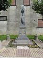
Fallen memorial
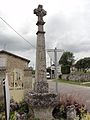
crossroads
.jpg)
_%C3%A9glise_(01).jpg)

.jpg)
_monument_aux_morts.jpg)
_croix_de_chemin.jpg)
Economy and Infrastructure
_%C3%A9cole_des_filles_et_salle_d%C3%A1sile.jpg)
The largest employer in the municipality is a traditional metalworking company that is now part of the Arcelor Mittal Group . In 1723 the company was founded as a forge ( Forges d'Haironville ). Reinforcing iron was initially produced here. Today the company mainly produces all kinds of steel profiles. There is a primary school, a post office and a few small shops including a bakery and butcher in the community. In Haironville there are also four farms (cultivation of grain, pulses and oilseeds).
The D 997 trunk road from Contrisson to Stainville and the D 4 trunk road from Brillon-en-Barrois to Cousances-les-Forges runs through Haironville, which follows the Saulx Valley . Five kilometers south of Haironville, the motorway-like Route nationale 4 runs from Saint-Dizier to Toul with a junction. The nearest train station is in the town of Saint-Dizier, 13 kilometers away, on the Blesme-Haussignémont-Chaumont railway line .
literature
- Le Patrimoine des Communes de la Meuse. Flohic Editions, Volume 1, Paris 1999, ISBN 2-84234-074-4 , pp. 48-50.
supporting documents
- ↑ place names on haironville.net
- ↑ toponym on cassini.ehess.fr
- ↑ Haironville on cassini.ehess.fr (French)
- ↑ Haironville to INSEE
- ^ Entry in the Base Mérimée of the Ministry of Culture. Retrieved June 3, 2019 (French).
- ^ Entry in the Base Mérimée of the Ministry of Culture. Retrieved June 3, 2019 (French).
- ↑ Farms on annuaire-mairie.fr (French)