
L'Isle-en-Rigault
| L'Isle-en-Rigault | ||
|---|---|---|

|
|
|
| region | Grand Est | |
| Department | Meuse | |
| Arrondissement | Bar-le-Duc | |
| Canton | Ancerville | |
| Community association | Communauté de communes des Portes de Meuse | |
| Coordinates | 48 ° 43 ' N , 5 ° 3' E | |
| height | 162-236 m | |
| surface | 10.54 km 2 | |
| Residents | 481 (January 1, 2017) | |
| Population density | 46 inhabitants / km 2 | |
| Post Code | 55000 | |
| INSEE code | 55296 | |

L'Isle-en-Rigault is a French commune with 481 inhabitants (as of January 1, 2017) in the Meuse department in the Grand Est region . It belongs to the Bar-le-Duc arrondissement and the Ancerville canton .
Neighboring municipalities are Robert-Espagne in the north, Trémont-sur-Saulx in the northeast, Ville-sur-Saulx in the east, Saudrupt in the southeast, Sommelonne in the south, Baudonvilliers in the southwest and Trois-Fontaines-l'Abbaye in the west.
Population development
| year | 1962 | 1968 | 1975 | 1982 | 1990 | 1999 | 2008 | 2017 |
|---|---|---|---|---|---|---|---|---|
| Residents | 650 | 627 | 610 | 607 | 609 | 532 | 535 | 481 |
Attractions
- former Saint-Hilaire church, built around 1160
- new church in Saint-Hilaire, built in 1857
- Saint-Christophe Chapel
- Fallen memorial
Castle of Jean d'Heurs, monument historique since 1972

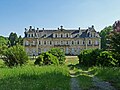
Castle of L'Isle-en-Rigault, monument historique since 1992

Castle of Trèves with castle park
.jpg)
_ch%C3%A2teau_(01).jpg)

literature
- Le Patrimoine des Communes de la Meuse. Flohic Editions, Volume 1, Paris 1999, ISBN 2-84234-074-4 , pp. 53-55.
Web links
Commons : Lisle-en-Rigault - collection of images, videos and audio files