
Fains-Véel
| Fains-Véel | ||
|---|---|---|

|
|
|
| region | Grand Est | |
| Department | Meuse | |
| Arrondissement | Bar-le-Duc | |
| Canton | Bar-le-Duc-2 | |
| Community association | Bar-le-Duc Sud Meuse | |
| Coordinates | 48 ° 47 ' N , 5 ° 8' E | |
| height | 170-272 m | |
| surface | 18.3 km 2 | |
| Residents | 2,140 (January 1, 2017) | |
| Population density | 117 inhabitants / km 2 | |
| Post Code | 55000 | |
| INSEE code | 55186 | |
| Website | http://www.fains-veel.fr/ | |
 Town hall and school building in the district of Fains-les-Sources |
||

Fains-Véel is a town in north-eastern France with 2140 inhabitants (as of January 1, 2017) in the Meuse department in the Grand Est region (until 2015 Lorraine ). The municipality belongs to the Arrondissement Bar-le-Duc and the canton Bar-le-Duc-2 (until 2015: Canton Bar-le-Duc-Nord ).
geography
Fains-Véel is located on the Ornain about three kilometers northwest of Bar-le-Duc . Fains-Véel is surrounded by the neighboring municipalities of Val-d'Ornain in the north and north-west, Chardogne in the north, Behonne in the east, Bar-le-Duc in the south-east, Combles-en-Barrois in the south, and Trémont-sur-Saulx in the south Southwest and Couvonges in the west and southwest.
history
In 1973 the communes of Fains-les-Sources and Véel were merged.
Population development
| year | 1962 | 1968 | 1975 | 1982 | 1990 | 1999 | 2006 | 2012 |
| Residents | 2426 | 2482 | 2588 | 2513 | 2447 | 2290 | 2283 | 2224 |
Attractions
- Sainte-Catherine church in the locality of Fains-les-Sources, monument historique since 1983
- Saint-Martin church in the locality of Véel, monument historique since 1927
- L'Hôpital chapel in Fains
- British military cemetery
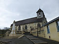
Sainte-Catherine church

Saint Martin Church
.jpg)
.jpg)
Personalities
- René II (1451–1508), Duke of Lorraine
literature
- Le Patrimoine des Communes de la Meuse. Flohic Editions, Volume 1, Paris 1999, ISBN 2-84234-074-4 , pp. 130-133.