
Rembercourt-Sommaisne
| Rembercourt-Sommaisne | ||
|---|---|---|

|
|
|
| region | Grand Est | |
| Department | Meuse | |
| Arrondissement | Bar-le-Duc | |
| Canton | Revigny-sur-Ornain | |
| Community association | Aire à l'Argonne | |
| Coordinates | 48 ° 55 ' N , 5 ° 11' E | |
| height | 223-307 m | |
| surface | 22.32 km 2 | |
| Residents | 353 (January 1, 2017) | |
| Population density | 16 inhabitants / km 2 | |
| Post Code | 55250 | |
| INSEE code | 55423 | |
| Website | http://arembercourtsommaisne.e-monsite.com/ | |

Rembercourt-Sommaisne is a French commune with 353 inhabitants (as of January 1, 2017) in the Meuse department in the Grand Est region (until 2015 Lorraine ). It belongs to the Arrondissement of Bar-le-Duc and the canton of Revigny-sur-Ornain (until 2015: Canton Vaubecourt ).
geography
Rembercourt-Sommaisne is located about 32 kilometers south-southwest of Verdun on the Aisne . Rembercourt-Sommaisne is surrounded by the neighboring communities of Pretz-en-Argonne in the north and north-west, Beausite in the north and north-east, Courcelles-sur-Aire in the east and north-east, Érize-la-Petite in the east, Les Hauts-de-Chée in the south and southeast, Lisle-en-Barrois to the west and Vaubecourt to the west and northwest.
history
In 1973 Rembercourt-aux-Pots and Sommaisne were merged to form the municipality of Rembercourt-Sommaisne.
| year | 1962 | 1968 | 1975 | 1982 | 1990 | 1999 | 2006 | 2013 |
|---|---|---|---|---|---|---|---|---|
| Residents | 372 | 362 | 369 | 354 | 349 | 313 | 321 | 338 |
Attractions
- Church Saint-Louvent 15th century monument historique since 1840
- Saint-Louvent chapel from 1949
- French national cemetery
- German military cemetery

Saint-Louvent church
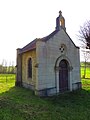
Saint-Louvent Chapel


literature
- Le Patrimoine des Communes de la Meuse. Flohic Editions, Volume 2, Paris 1999, ISBN 2-84234-074-4 , pp. 1012-1015.