
Loisey
| Loisey | ||
|---|---|---|

|
|
|
| region | Grand Est | |
| Department | Meuse | |
| Arrondissement | Bar-le-Duc | |
| Canton | Vaucouleurs | |
| Community association | Bar-le-Duc Sud Meuse | |
| Coordinates | 48 ° 46 ′ N , 5 ° 17 ′ E | |
| height | 212-364 m | |
| surface | 13.46 km 2 | |
| Residents | 300 (January 1, 2017) | |
| Population density | 22 inhabitants / km 2 | |
| Post Code | 55000 | |
| INSEE code | 55298 | |
| Website | www.loisey.fr | |
 Partial view of the community |
||

Loisey is a French commune with 300 inhabitants (as of January 1, 2017) in the Meuse department in the Grand Est region ( Lorraine until 2015 ); it belongs to the District Bar-le-Duc and the Association of Municipalities Bar-le-Duc Meuse Sud . The municipality was part of the canton of Ligny-en-Barrois until 2015 .
geography
Loisey is located around 9 kilometers east of the small town of Bar-le-Duc in the south of the Meuse department. The place is on the Ruisseau de Culey . Large parts of the municipality are forested.
Neighboring municipalities are Érize-Saint-Dizier and Géry in the north, Lavallée in the northeast, Salmagne in the east and Culey in the south and west.
history
Like all parishes in the area, the parish suffered from conflict in the Middle Ages. The worst devastation was caused by the Hundred Years War and the Thirty Years War . The name of today's community was first mentioned in a document in 825 under the Latin name Lauziacus . In the Middle Ages, the community belonged to the Barrois mouvant and was part of the Champagne . It was subordinate to the Kastlanei Pierrefitte in the Bailliage Bar. Loisey belonged to the District Bar-sur-Ornain (today Bar-le-Duc) from 1793 to 1801. From 1793 to 1801 it was the capital of a canton. From 1801 to 2015 Loisey was part of the canton of Ligny-en-Barrois . The municipality has been assigned to the Arrondissement of Bar-sur-Ornain (today Bar-le-Duc) since 1801. From 1973 to July 1, 2014, she was united with the neighboring community of Culey to form the community of Loisey-Culey.
Population development
Despite its proximity to the small town of Bar-le-Duc, the rural exodus was as pronounced as in many small communities in France. The population shrank from the peak in 1841 to 1990 by 69.4 percent.
| year | 1793 | 1841 | 1851 | 1911 | 1946 | 1962 | 1968 | 1975 | 1982 | 1990 | 1999 | 2006 | 2011 | 2016 |
| Residents | 798 | 854 | 838 | 375 | 288 | 370 | 400 | 296 | 271 | 261 | 305 | 301 | 304 | 303 |
| Sources: Cassini and INSEE ; Figures for 1975 to 2011: INSEE - Populations communales pour chaque recensement de 1876 à 2015 | ||||||||||||||
Attractions
- Saint-Remi village church
- Memorial to the fallen in the cemetery
- Memorial to the fallen in front of the post office
- five wayside crosses on the arterial roads around the village
- Fountain with lion sculpture
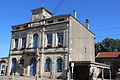
Town hall (Mairie) by Loisey

Saint-Remi village church
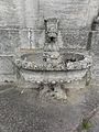
Fountain with lion sculpture

Wayside cross near the church
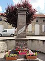
Memorial to the fallen in front of the post office

Village and Ruisseau de Culey


_fontaine_sculpt%C3%A9e.jpg)
_croix_enceinte_de_l%27%C3%A9glise.jpg)
_monument_aux_morts.jpg)
_ruisseau_dans_le_bourg_de_Loisey.jpg)
traffic
In terms of transport, the community is a few kilometers north of Route nationale 4 with the next connection in Ligny-en-Barrois. The D6 and N135 are important for regional traffic.
The railway line from Nancy to Bar-le-Duc, which is served by TER Lorraine , passes a few kilometers to the west and south of the municipality . Closest stops are Bar-le-Duc and Nançois-Tronville.
literature
- Le Patrimoine des Communes de la Meuse. Flohic Editions, Volume 1, Paris 1999, ISBN 2-84234-074-4 , pp. 528-531.