Sommelonne
| Sommelonne | ||
|---|---|---|

|
|
|
| region | Grand Est | |
| Department | Meuse | |
| Arrondissement | Bar-le-Duc | |
| Canton | Ancerville | |
| Community association | Portes de Meuse | |
| Coordinates | 48 ° 40 ′ N , 5 ° 2 ′ E | |
| height | 165-230 m | |
| surface | 10.22 km 2 | |
| Residents | 455 (January 1, 2017) | |
| Population density | 45 inhabitants / km 2 | |
| Post Code | 55170 | |
| INSEE code | 55494 | |
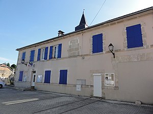
 Town hall ( Mairie ) of Sommelonne |
||
Sommelonne is a French commune with 455 inhabitants (as of January 1, 2017) in the Meuse department in the Grand Est region (until 2015 Lorraine ). The municipality is part of the Bar-le-Duc arrondissement , the canton of Ancerville and the Portes de Meuse municipal association founded in 2016 .
geography
The municipality is crossed by the small river Ornel. Surrounded Sommelonne of the neighboring communities Baudonvilliers in the northwest, L'Isle-en-Rigault in the north, Saudrupt in the Northeast, Haironville the east, Rupt-aux-Nonains in the southeast, the cantonal capital Ancerville in the southwest, as well as the in the Haute-Marne located community Chancenay in the west.
Origin of name
The name, which comes from Latin, means "The source of the Ornel". The place was mentioned in a document in 1146 as Summelongne and in 1181 with its current name.
Population development
| year | 1962 | 1968 | 1975 | 1982 | 1990 | 1999 | 2004 | 2009 | 2016 |
| Residents | 305 | 344 | 325 | 347 | 462 | 479 | 501 | 500 | 469 |
| Source: Cassini and INSEE | |||||||||
Attractions
- Saint Vincent Church
- War memorial
literature
- Le Patrimoine des Communes de la Meuse. Flohic Editions, Volume 1, Paris 1999, ISBN 2-84234-074-4 , pp. 63-64.


