Baldwin Peninsula
| Baldwin Peninsula | ||
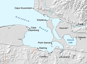
 The Kotzebue Sound with the village of Kotzebue on the northern tip of the Baldwin Peninsula |
||
| Geographical location | ||
|
|
||
| Coordinates | 66 ° 40 ′ N , 162 ° 6 ′ W | |
| Waters 1 | Chukchi Sea ( Arctic Ocean ) | |
| length | 72 km | |
| width | 19 km | |
The Baldwin Peninsula is located on the Arctic Circle in the northwest of the US state Alaska . It extends 72 km in a north-westerly direction into the Kotzebue Sound . The width of the peninsula is 19 km at its widest and 2 km at its narrowest point.
The city of Kotzebue and the Ralph Wien Memorial Airport are located at the northern end of the Baldwin Peninsula. This is where the Hotham Inlet ends , into which the Kobuk and Selawik rivers flow. In the southeast of the peninsula is the Selawik Lake .
The peninsula was named in 1933 by Carl Joys Lomen (1880-1965) of the Lomen Reindeer Corporation after Leonard D. Baldwin (1867-1933).
Web links
Commons : Baldwin Peninsula - collection of pictures, videos, and audio files
