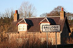
Ballogy
|
Scottish Gaelic Ballogy Baile Lagaidh |
||
|---|---|---|
| Entrance to Ballogie | ||
| Coordinates | 57 ° 3 ′ N , 2 ° 42 ′ W | |
|
|
||
| administration | ||
| Post town | ABOYNE | |
| ZIP code section | AB34 | |
| prefix | 01339 | |
| Part of the country | Scotland | |
| Council area | Aberdeenshire | |
| British Parliament | West Aberdeenshire and Kincardine | |
| Scottish Parliament | Aberdeenshire West | |
Ballogie ( Gaelic : Baile Lagaidh ) is a village in the Scottish Council Area Aberdeenshire . It is located about five kilometers southeast of Aboyne and 37 km southwest of central Aberdeen on the Burn of Cattie . The Dee runs about two kilometers north, which is why Ballogie is part of the Lower Deeside region .
history
The history of Ballogie is linked to the property of the same name. The present mansion, Ballogie House, dates from the 1850s. Various buildings are listed on the extensive property. To the northeast is the former shoemaker 's shop , Souter's Shop , which is classified as a monument of the highest Scottish category A. Together with the adjacent residential building Muir Croft , it also forms a category B monument ensemble.
Today Ballogie only exists as a small scattered settlement.
traffic
The B976 , which runs from Strachan to beyond Crathie , passes the village to the east . Just like the B993 branching off from it, it connects Ballogie in the north and east to the A93 trunk road ( Perth -Aberdeen). Aberdeen International Airport is approximately 35 kilometers to the northeast.
Web links
Individual evidence
- ^ Information from the Scottish Parliament
- ^ Entry in the Gazetteer for Scotland
- ↑ Entry on Ballogie in Canmore, the database of Historic Environment Scotland (English)
- ↑ Listed Building - Entry . In: Historic Scotland .
- ↑ Listed Building - Entry . In: Historic Scotland .
- ^ Map of the Ordnance Survey
- ↑ Measurement on Google Maps


