Balsfjord (inlet)
| Balsfjord Báhccavuotna |
||
|---|---|---|
|
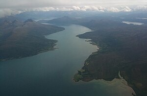
Entrance to the Balsfjord |
||
| Waters | European Arctic Ocean | |
| Land mass | Scandinavian peninsula | |
| Geographical location | 69 ° 28 ′ 30 ″ N , 18 ° 56 ′ 6 ″ E | |
|
|
||

Balsfjord ( North Sami Báhccavuotna ) is a fjord in the municipalities of Tromsø and Balsfjord in Troms og Finnmark in Norway . The fjord extends 49 km south from the mouth of the fjord to Nordkjosbotn at the head of the fjord.
The fjord has its mouth between the Balsnesodden peninsula in the west and Ytre Berg in the east, a little south of Tromsø . To the west of Balsnesodden, the Straumsfjord begins to the west along the south side of the island of Kvaløya . Between the peninsula and the village Ramfjordneset Andersdal on the west side just south of the mouth of the branches Ramfjord off to the east. This is the only arm of the fjord in the Balsfjord. Opposite Andersdal is Kobbevågen.
The area of the municipality of Balsfjord begins a little further in the interior of the fjord . Stornes is a hamlet on the east side of the fjord just after the municipality boundary and a little further south is the hamlet of Storbukta. A little further in the interior of the fjord is the place Malangseidet on the west side. The west side of the Balsfjord is dominated by high mountains, but a valley branches off at Malangseidet, which leads to the tip of the Malangsfjord (also in Norwegian Malangen ) and to the Nordfjord . Across from Malangseidet is Svartnes and here the Balsfjord curves to the east. Along this stretch are the villages of Middagsbukta and Sletta and the hamlet of Sandøyra on the south side. The hamlet of Kantornes is on the north side, and at the village of Laksvatn a little further to the east the fjord turns south again.
Storsteinnes , the community center of Balsfjord, is on the inside of Sørkjosen bay in the far south of the fjord. There the Balsfjord turns again to the east and ends in Nordkjosbotn where the European roads E6 and E8 unite. The innermost part of the fjord is called Nordkjosen.
The E8 runs north on the east side of the fjord to Kantornes. The E6 follows the south side of the fjord in the innermost part. Other roads around the fjord are the N859 ( Norwegian Riksvei 859 ) along the west side north of Storsteinnes and the N858 ( Norwegian Riksvei 858 ) along the west side further north of Malangseidet out of the fjord. Regional road 294 ( Norwegian Fylkesvei 294 ) runs along the east side of the fjord from Kantornes to Andersdal, and regional road 297 ( Norwegian Fylkesvei 297 ) runs on the south side south of Kantornes .
The name Balsfjord våtmarksystem covers two protected wetlands:
- Kobbevågen nature reserve, established December 8, 1995 with 6.2 km²
- Sørkjosleira nature reserve, established December 8, 1995 with 3.7 km²
Both consist of salt meadows, silt and sand banks that are influenced by the tides. These areas are designated as bird sanctuaries according to the Ramsar Convention .

