
Bannockburn (Scotland)
|
Bannockburn Scottish Gaelic Allt a 'Bhonnaich |
|||
|---|---|---|---|
 |
|||
| Coordinates | 56 ° 5 ′ N , 3 ° 55 ′ W | ||
|
|||
| Residents | 6979 2011 census | ||
| administration | |||
| Post town | STIRLING | ||
| ZIP code section | FK7 | ||
| prefix | 01786 | ||
| Part of the country | Scotland | ||
| Council area | Stirling | ||
| British Parliament | Stirling | ||
| Scottish Parliament | Stirling | ||

Bannockburn ( Scottish Gaelic : Allt a 'Bhonnaich ) was the name of a village in central Scotland , the name of which is derived from the brook Bannock ( burn : Scots for "brook"), which flows into the Forth . Due to steady growth in the age of industrialization, Bannockburn expanded to the city limits of nearby Stirling and eventually became part of that city.
The village became famous for the Battle of Bannockburn , one of the decisive battles in the Scottish Wars of Independence , in which the Scottish army, led by Robert the Bruce, inflicted a heavy defeat on the English army under Edward II in 1314 . On the former battlefield in the south of Stirling, where the battle was finally decided, an abstract memorial today commemorates the battle. This, along with an equestrian statue of Bruce and the adjacent visitor center, is one of the area's most popular tourist attractions.
Sons and Daughters of Bannockburn
- Gary Liddell (1954-2015), football player

The avenue to the monument

The semicircular wall of the monument
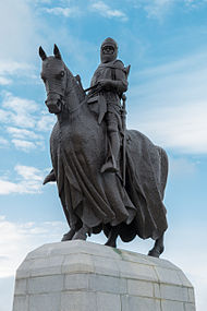
The equestrian statue of Robert the Bruce by Pilkington Jackson

The equestrian stand with base


