
Bargis


Bargis refers to an alp (and colloquially a high valley ) in the canton of Graubünden in Switzerland . The valley is located northeast of Flims in the municipal area of Trin (east of the river) and Flims. It is traversed by the Aua da Mulins, which after leaving the valley floor in the now Val Turnigla valley flows further south as Turnigla and flows south of Trin Mulin into the Flem .
The name is derived from the Rhaeto-Romanic word Bargia , which was transformed into Bargis by the German-speaking Walsers in Fidaz .
geography

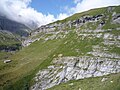
The high valley lies behind a rock bar over a slope to Trin Mulin, which was created by the Flims landslide . The first accessible floor of the valley is at an altitude of around 1550 meters and is used for pastures with a few stables and alpine huts (some as holiday homes).
In this front part there is often no surface water flowing in midsummer - neither the Aua da Mulins nor the creek from Val Lavadignas - although the waterfalls rush in both of them further back in the valley: after about two kilometers the flat valley floor narrows and the valley rises to an altitude of almost 1900 meters. The second valley chamber again forms a floor with an alpine hut, where the road ends. At the end of this floor is a small gorge with two waterfalls pouring into it. This place is visited by people who seek places of power, and called by them a cathedral .
Above the second floor there are two more Alps (Raschaglius Sut and Sura), which can only be reached on foot. A hiking trail continues here to Fuorcla Raschaglius, from where the Cassonsgrat or the Segnasboden can be reached. In the west and in the rear part in the south, the Bargis valley is bounded by the steep walls of the Flimserstein , while to the north and north-east the side valleys Val Sax, Val Camutschera (twice, the lower part of Val Sax is also called this) and Val Lavadignas branch off. The valley is bounded to the northwest by the Piz Dolf and in the north by the Piz Sax, Piz da Sterls and Ringelspitz .
Strictly speaking, the whole valley has no name, it is rather the inaccessible runways that were named, as well as the Alps (Bargis, Lavadignas, La Rusna, Raschaglius). In Trin Mulin (German and no longer common: Trinser Mühle ) the water reaches the location of the mill of Trin (a former sawmill is still visible) and today's hydroelectric power station, which uses the gradient of the last 140 meters. The high valley was (presumably) not even evaluated as a location during the dam wall euphoria in the 1950s, as too much water obviously seeps away.
“Scala Mola” alpine path

From Gasthaus Bargis, a path carved into the rock leads around 500 meters in altitude up to the Flimserstein Alps. In 1645 the path was expanded: documented and apparently we are very unanimous with this present letter and like a honorable community Flimbs from raht gueter lerern and wysen master [...] made a new path through the stone into the upper alp with the creature ... the up According to the historian JA von Sprecher, this type of renewed path was still so dangerous at the end of the 18th century that every year some animals fell into the abyss.
In 1867/1868 the Flims town council had Italian workers blast a better path into the rock for 10,200 francs, which is still used today. However, today's route no longer follows the entire length of the route originally blasted out; the bypassed part is the lower quarter in the upper rock slab.
Every September there is a descent from the Alps in Bargis , during which the decorated cows are brought back from Flimserstein to Flims and Fidaz.
Infrastructure
A postbus course leads from Flims via Fidaz to Bargis. In winter there are 7.5 kilometers of cross-country trails and a small cross-country center with changing rooms. The Berghaus Bargis offers catering options in summer and winter. Access with private cars is not permitted.
gallery
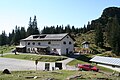
Bargis inn
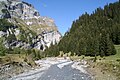
Aua da Muligns

View to the northeast into Val Lavadignas, to the left of the Mirutta separated from the Bargistal
Outflow of the Aua da mulegns

The «guard» in the Bargistal

"Cathedral" entrance

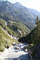
Upper and lower level in the Bargistal valley
The (lower) level of Bargis seen from Fil
Above the cathedral, the left valley under the Flimserstein leads to the west, the Val Sax to the northwest. In between lies the Alp Raschaglius Sut.

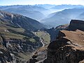
The valley to Bargis in the south-east direction, seen from the direction of Piz Dolf. The bottom of Bargis can be seen to the left of the steep cliff edge.


Varia
In 2006, the ZDF in Bargis realized an autumn show on the date of the Alp departure from Alp Flimserstein to Bargis.
Web links
Individual evidence
- ↑ Andrea Schorta: How the mountain got its name; Terra Grischuna-Verlag, Chur 1999
- ↑ Hiking Switzerland; Bargistal and Fil de Cassons on holiday in Graubünden ( Memento of the original from June 7, 2011 in the Internet Archive ) Info: The archive link was inserted automatically and has not yet been checked. Please check the original and archive link according to the instructions and then remove this notice.
- ^ Hermann Anliker: Swiss home books: Flims. Haupt-Verlag, Bern 1961.
- ↑ Cross-country skiing ( Memento of the original from November 14, 2011 in the Internet Archive ) Info: The archive link was automatically inserted and not yet checked. Please check the original and archive link according to the instructions and then remove this notice.
- ↑ http://www.presseportal.de/pm/7840/867010/alles-kiwi-die-herbstshow-auftakt-zu-fuenf-zdf-musiksendung-mit-andrea-kiewel
Coordinates: 46 ° 51 '25.6 " N , 9 ° 18' 59.4" E ; CH1903: 743,190 / 191266