Barnes Bluff
| Barnes Bluff | ||
|---|---|---|
| location | Marie Byrd Land , West Antarctica | |
| part of | Jones Bluffs | |
|
|
||
| Coordinates | 74 ° 46 ′ S , 110 ° 19 ′ W | |
|
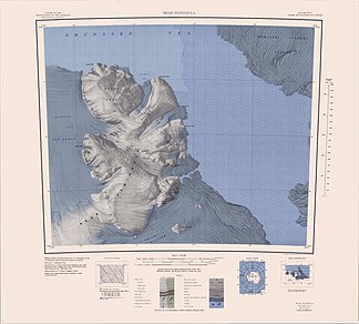
Map of the Bear Peninsula with Jones Bluffs and Barnes Bluff (below the center of the map) |
||
The Barnes Bluff is a rock cliff at the Walgreen Coast of the West Antarctic Marie Byrd lands . It is an extension of the Jones Bluffs on the east side of the Bear Peninsula and is 2.5 km north-northeast of Eckman Bluff .
The United States Geological Survey mapped the cliff using its own surveys and aerial photographs of the United States Navy from 1966. The Advisory Committee on Antarctic Names named it in 1977 after Lieutenant Commander John O. Barnes of the US Navy, officer in charge of air operations during both Operation Deep Freeze from 1975 to 1976 and from 1976 to 1977 as well as officer on duty of the delegation of the Naval Support Force Antarctica at McMurdo Station in the Antarctic winter of 1977.
Web links
- Barnes Bluff in the Geographic Names Information System of the United States Geological Survey (English)
- Barnes Bluff on geographic.org (English)

