Barrière (British Columbia)
| Barrier | ||
|---|---|---|
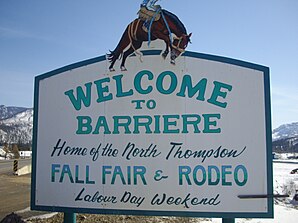
 Place name sign of Barrière |
||
| Location in British Columbia | ||
|
|
||
| State : |
|
|
| Province : | British Columbia | |
| Regional District : | Thompson-Nicola Regional District | |
| Coordinates : | 51 ° 11 ′ N , 120 ° 7 ′ W | |
| Height : | 415 m | |
| Area : | 10.77 km² | |
| Residents : | 1713 (as of 2016) | |
| Population density : | 159.1 inhabitants / km² | |
| Time zone : | Pacific Time ( UTC − 8 ) | |
| Postal code : | V0E 1E1 | |
| Foundation : | 2007 ( incorporated ) | |
| Mayor : | Ward Stamer | |
| Website : | www.districtofbarriere.com | |
| Climate diagram | ||||||||||||||||||||||||||||||||||||||||||||||||
|---|---|---|---|---|---|---|---|---|---|---|---|---|---|---|---|---|---|---|---|---|---|---|---|---|---|---|---|---|---|---|---|---|---|---|---|---|---|---|---|---|---|---|---|---|---|---|---|---|
| ||||||||||||||||||||||||||||||||||||||||||||||||
Barrière is an independent municipality in the Canadian province of British Columbia .
It is 40 miles north of the larger town of Kamloops on Highway 5 .
history
The town was originally the site of a fur trading post and derives its name from the rocks and nets in the water that the First Nations placed in the river as a barrier to prevent boats from passing.
In 1861 gold was discovered and mined in the area.
In 2003, a major forest fire swept the area, destroying both homes and industry. This also included the Louis Creek sawmill, a large local employer.
The award of local self-government for the municipality took place on October 4, 2007 ( incorporated as District Municipality ).
Demographics
The 2016 census showed a population of 1,713 inhabitants for the settlement, after the 2011 census for the municipality still showed a population of 1,773 inhabitants. The population increased by 3.4% compared to the last census in 2011 and thus developed against the provincial average, with a population increase of 5.6% in the province. In the census period 2006 to 2011, the number of inhabitants in the municipality had decreased by 23.8%, while the provincial average increased by 7.0%.
At the 2016 census, the average age of the residents was 48.4 years, well above the provincial average of 42.3 years. The median age of the residents was determined to be 54.0 years. The median age of all residents in the province in 2016 was 43.0 years. For the 2011 census, a median age of 55.2 years was determined for the residents of the municipality and 41.9 years for the residents of the province.
religion
There are the following churches in Barrière:
- Bethany Baptist Church ( Baptisten , Fellowship of Evangelical Baptist Churches in Canada )
- Christian Life Assembly ( Pfingstler / Assemblies of God , Pentecostal Assemblies of Canada )
- St. George ( Catholics , Diocese of Kamloops )
- St. Paul (merged congregation of the Anglican , the United and the Evangelical Lutheran Church )
- Seventh-day Adventists
- Jehovah's Witnesses
Infrastructure
The closest hospital to the region is the Royal Inland Hospital in Kamloops .
One of the main reasons the community is growing is its location on Highway 5, the only possible route into interior of northern British Columbia, Jasper and Edmonton . The rail network of the Canadian National Railway also runs through the place.
Industry
Barrieres most important industry is the forest industry, but tourism and agriculture are also important.
The city's top employers are Gilbert Smith Forest Products and Darfield Building Products , for which about 75% of residents work.
Recreation and sport
- The community is in the middle of a three-phase park rejuvenation project.
- Several swimming lakes are only a short drive away from the community.
- North of the city center is the Chinook Cove Golf Course .
- The Sun Peaks Ski Area is around an hour's drive from Barriere.
Events
- On Labor Day , the first Monday in September, the site hosts the North Thompson Fall Fair Rodeo . Around 10,000 people visit the 3-day fair every year, during which a large parade takes place.
Personalities
- Wayne Broomfield, outdoor painter, lives in Berriere most of the year.
Web links
Individual evidence
- ↑ a b Barrière Community Profile. Census 2016. In: Statistics Canada . August 9, 2019, accessed September 1, 2019 .
- ^ Origin Notes and History. Barrier. GeoBC , accessed August 9, 2012 .
- ^ Barrière Community Profile. Census 2011. In: Statistics Canada . May 31, 2016, accessed September 1, 2019 .
