
Barwon River (Bass Strait)
| Barwon River | ||
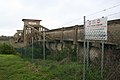
 The Barwon Heads Bridge not far from the estuary |
||
| Data | ||
| location | Victoria , Australia | |
| River system | Barwon River | |
| source | Otway Ranges | |
| muzzle | between Ocean Grove and Barwon Heads in Bass Street Coordinates: 38 ° 16 ′ 56 " S , 144 ° 29 ′ 47" E 38 ° 16 ′ 56 " S , 144 ° 29 ′ 47" E
|
|
| length | 160 km | |
| Catchment area | 8590 km² | |
| Medium-sized cities | Geelong | |
The Barwon River is a river in southern Victoria , Australia .
course
The source of the Barwon River is in the Otway Ranges . The river flows north first, east to Winchelsea, until it reaches the town of Geelong , where the Moorabool River joins .
The Barwon River flows through the southern districts of the port city of Geelong , but does not flow into Corio Bay, only two and a half kilometers away , but changes its course to the southeast. A series of bridges span the river in Geelong. The single-lane Queens Bridge in the Newtown district is unusual . With several parks, the Barwon River is a popular recreational area for Geelong.
The river then crosses the Bellarine Peninsula and flows through Lake Connewarre . It flows into the Bass Strait between Ocean Grove and Barwon Heads southeast of Geelong.
The river's water is used for agriculture and industry. Water skiing is practiced on the Barwon River. Rowing regattas such as the Head of the River are also held.
Sewer aqueduct for sewage

Weir at Buckley's Falls

Breakwater Bridge in East Geelong


