Bashistrasse
| Bashistrasse | ||
|---|---|---|
| Map of Luzonstrasse | ||
| Connects waters | Philippine Sea | |
| with water | South China Sea | |
| Separates land mass | Luzón | |
| of land mass | Taiwan | |
| Data | ||
| Geographical location | 21 ° 25 ′ N , 121 ° 30 ′ E | |
|
|
||
| Smallest width | 250 km | |
| Islands | Lan Yu , Y'Ami Island | |
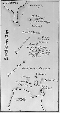
The Bashi Channel ( Chinese 巴士 海峽 , Pinyin Bā shì hǎi xiá , Japanese バ シ ー 海峡 , English Bashi Channel ) is a waterway that connects the Philippine Sea with the South China Sea between the island of Lan Yu ("Orchid Island") of Taiwan and the Philippine island of Y ' Ami Island connects. It forms part of the Luzon Strait in the Pacific .
geography
The waterway, unlike the Babuyan Canal and Balintang Canal, is closer to Taiwan and the distance between the islands is 80 to 90 km. It is not actually a real "canal", the ridge that carries the islands runs under the sea, across the waterway with a varied topography. The edges of the waterway on the Taiwan side are marked by the reefs Qixingyan (Taiwan) and Cape Eluanbi .
Bashistrasse is an important passage for military operations. Taiwan and the Philippines are fighting over sovereignty over this area because both sides claim their 200-mile zone in the waters. The People's Republic of China is also holding military exercises in the area.
In addition, numerous submarine cables for data and telephone traffic between the Asian countries run through Bashistraße, so that earthquakes and disasters in this zone have widespread effects. In December 2006, for example, a submarine earthquake with a magnitude of 6.7 damaged several cables, creating a bottleneck that lasted for several weeks.
literature
- Sei-ichi Kanari, Toshihiko Teramoto: Bashi channel, Luzon strait: A hydraulic model experiment of the tidal current In: Journal of Oceanography. March 1981, Vol. 37, 1: 31-48 , Journal of the Oceanographical Society of Japan [1]
- Xiaolong Zhao, Chun Zhou, Wei Zhao, Jiwei Tian, Xiaobiao Xu: Deepwater overflow observed by three bottom-anchored moorings in the Bashi Channel. In: Deep Sea Research Part I: Oceanographic Research Papers. April 2016, Vol. 110: 65-74. [2]
Web links
- China's Growing Military Activity Around Taiwan Triggers Alarm. Michal Thim, Taiwan Sentinel . January 8, 2018.
- Ankit Panda: China's Air Force Revisits the Bashi Channel. Here's Why That Matters. The Bashi Channel is seldom discussed, but bears great strategic relevance for the People's Liberation Army. In: The Diplomat. , September 13, 2016.
- Arthur Dominic Villasanta: PLAAF Patrol Overflies Bashi Channel; Again Pierces 'First Island Chain'. www.chinatopix.com, September 15, 2016.
Individual evidence
- ↑ Index to the New Map of China (In English and Chinese) Far Eastern Geographical Establishment, Shanghai 1914: 142.
- ↑ China's Air Force Revisits the Bashi Channel. Here's Why That Matters. In: The Diplomat. 2016.
- ↑ Sumner Lemon: Earthquakes Disrupt Internet Access in Asia; A Series of Powerful Earthquakes Damages Undersea Cables and Interrupts Internet Connections in Asia . December 27, 2006. Archived from the original on January 3, 2007. Retrieved on December 27, 2006.
- ↑ PINR report, Taiwan Quake Exposes Internet Vulnerability. January 15, 2007.

