Eluanbi
Eluanbi or Eluan ( Chinese 鵝 鑾 鼻 , Pinyin É luán bí ; also: Taiwan Zuinan dian台灣 最 南 點; Táiwān Zuì Nán Diǎn) is the southernmost point of the island of Taiwan (Formosa). The area is designed as Eluanbi Park (鵝 鑾 鼻 公園, Éluánbí Gōngyuán), which is part of Kenting National Park , and is located in the parish of the township of Hengchun in Pingtung County .
Surname
Eluanbi was probably originally a Chinese description of the local name “goran; Gô-lôan-phīⁿ ”, the Paiwan word for“ sail ”. The Chinese characters "鵝 鑾 鼻" literally mean " goose - bell - nose ". However, this designation is likely to have originated from the Chinese transcription of the local Hokkien dialect, which is pronounced roughly Gô-lôan and in reality is only likely to be the rendering of the Paiwan- goran . This name probably refers again to the nearby Sail Rock . “Bi” - the nose - is the dialect name for a headland or peninsula, similar to the nearby Maobitou .
The area was known as "Linhaishan" by the Qing . Cape Garan Bi was named under Japanese rule . after the Japanese pronunciation of the Chinese characters. Other writes are Eluan Pi , Oluanpi ;, Gaw loan-phi , Ngoluanpi or Goa-loan-pi according to the discussion in Hokkien dialect. Sometimes it is also called the South Cape .
geography
Eluanbi is the southernmost point of the Hengchun Peninsula and thus the southernmost point on the island. The area is geologically shaped by the so-called Eluanbi Beds (层, céng), a Pleistocene rock layer of yellow and brown sands , gravel and mudstone . The nearby hills are an extension of Taiwan's Central Mountains (geb 山脈 Zhōngyāng Shānmài).
The international border between the East China Sea and the South China Sea is currently located at Cape Fugui , at the northernmost point of Taiwan. Eluanbi, - mostly under the Japanese name "Garan Bi" - forms part of the border between the East China Sea and the Philippine Sea . However, the still unapproved new division of the International Hydrographic Organization (IHO), Limits of Oceans and Seas , sets part of the northern border of the South China Sea at "Eluan Cape", together with the southern border of the Formosa Strait and parts of the western border of the Philippine Sea.
However, Eluanbi can also be assigned to the Luzon Strait and the Bashi Channel between Taiwan and the Philippines .
history
prehistory
Archaeological finds suggest that there was a prehistoric settlement at Eluanbi, which dates back to around 3100 BC. C. lets date. The remains resemble those of the Xiantao culture that were discovered in nearby Taitung . The local name is "Oluanpi-I". Pottery and textiles were from age "Kenting" are detected from about 2500 BC. Around 1500 BC the inhabitants of "Oluanpi-III" gave up farming in the lowlands and withdrew to more defensible communities in the highlands; he developed "Oluanpi-IV" around 50 BC. C. Around the same time, the independent Hsiang-lin culture settled in the river valleys and lowlands; the Kueishan culture followed around the 2nd century and the Americans around the 5th century. By that time, hunting had become a ritual and a leisure activity for the well-developed agricultural communities. The Paiwan eventually replaced the peoples in the highlands as they migrated from the north. The Siraya , from their legendary origins in Xiaoliuqiu , moved into the lowlands from the 8th century and were the first to become strongly Sinic .
Qing Dynasty
During the early Qing Dynasty , the area around the peninsula remained in the hands of indigenous tribes such as the Paiwan . The strong currents and the nearby Qixingyan reefs led to numerous shipwrecks and also led to international tensions, for example in the case of the rovers (羅 發 號 事件 Luó fā hào shìjiàn) in 1867 and the Mudan incident (Ryukyu convoy, 八 瑤 灣 事件 Bā yáo wān shìjiàn) 1871. Both incidents led to military expeditions by the Americans ( American punitive expedition to Formosa 1867 ) and Japanese respectively .
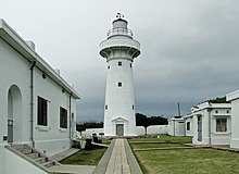
The American consul in Amoy (today: Xiamen ), Charles Le Gendre , informed the viceroy of Liangjiang (兩 江 總督 Liǎng jiāng zǒng dū) Shen Baozhen about the risk to the Chinese state if China should take control of the indigenous territories on the Island do not perceive. Shen then reformed the civil and military administration in Taiwan and launched attacks against resisting tribes. He also started a program to build public works on the south coast, including a lighthouse in Eluanbi ( lighthouse Eluanbi鵝 鑾 鼻 燈塔, É luán bí dēngtǎ). The construction of the lighthouse fell within the scope of the British diplomat Robert Hart , who was responsible as Inspector General of the Imperial Maritime Customs Service . In 1875 he sent agents to acquire the southern cape from the chiefs of the Kuie Chia Chiao (龜 仔 角; Guīzǎijiǎo ). This gesture did not prevent the indigenous Paiwan and other tribes from raiding and attacking the Chinese construction project. Guard troops first had to be deployed and fortifications had to be built in Eluanbi. The lighthouse itself was finally built between 1881 and 1883. It was put into operation on April 1, 1883.
The lighthouse, its crew and its garrison were initially looked after by British officers from the Imperial Maritime Customs Service and German military officers. The area was equipped with 18-pounder long gun cannons, Gatling guns and a mortar . Supplies were held for a possible siege period of three weeks.


Japanese Empire
The buildings of the Qing Dynasty were badly damaged during the First Sino-Japanese War. It was the Qing troops themselves who tried to destroy the fortifications as they withdrew. The facilities were repaired in 1898 when Japan took Taiwan under its rule . It was also around this time that the cape was recognized as the southernmost point of the island, and the lighthouse was commercialized by the Japanese as one of the Eight Landmarks of Taiwan (臺灣 八景 Taiwan ba jing).
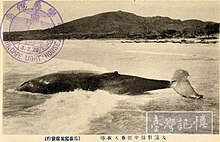
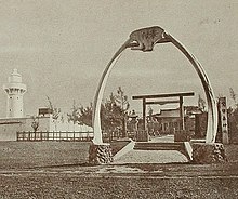
The cape was also an important whaling station for Japanese whaling , with humpback whales being brought ashore in Banana Bay and South Bay . The importance for the whaling industry was underlined by the architecture of Shinto - shrine , which was one of only five shrines in the world, the Torii of baleen - pines were formed.
The lighthouse was again badly damaged in World War II during the air battle for Taiwan and Okinawa (Japanese: 台湾 沖 航空 戦, Chinese: 臺灣 空戰) and the shrine was also destroyed during this time.
Republic of China
The Kuomintang - Taiwan government allowed the lighthouse in 1947 to rebuild. The accidental discovery of several stone sarcophagi near the lighthouse in 1956 led to archaeological investigations by Sung Wen-tung and Lin Chao-chi in the same year and again in 1966. The area around the lighthouse was converted into a national park in 1982 . Additional prehistoric relics were found during the construction of paths and trails prior to opening in 1981, and further excavations were carried out under Li Kuang-chou over the next two years .
In 1992, the Eluanbi lighthouse was one of the first lighthouses in Taiwan to be opened to the public. The success motivated the sea and port authorities (交通部 航 港 局, jiāo tōng bù háng gǎng jú) to open the lighthouses in other places as well. In 2014, more than 300,000 visitors a year came, many of them tourists from mainland China .
park
The cape is with 59 hectares of the area, the Eluanbi Park (Éluánbí Gōngyuán), part of the larger Kenting National Park , which includes the southern end of the Hengchun Peninsula.
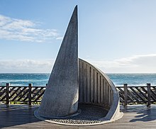
A viewing platform with a stone marker at the southernmost point has become a tourist attraction.
Fishing and water sports are common, but there are some nature reserves such as Longkeng Protected Landscape Area (龍 坑 生態 保護 區; 龙 坑 生态 保护 区Lóngkēng Shēngtài Bǎohùqū ). Around Banana Bay, the Longkeng Reserve protects coral reefs and a piece of primary forest . Large whales are rarely found in the sea around Eluanbi, but there are still smaller whale species such as dolphins , sea turtles , and bull sharks . In particular, the 26 different species of land crabs that live in the area make the Cape the most biologically diverse land crab place in the world.
Individual evidence
- ↑ in the local dialect: ngo4 lyun4 bei6, other terms are Japanese 鵝 鑾 鼻; が ら ん び , Garanbi, English Cape Eluanbi
- ↑ EB 1879: 415.
- ↑ IHO 1953: §49.
- ↑ a b c Zhang 2009: 827 .
- ^ A b c Wang Shu-fen, Frances Huang: Taiwan to Open Two More Lighthouses to Visitors. focustaiwan.tw Focus Taiwan Wang & al. February 21, 2015.
- ^ Campbell 1896: map
- ↑ IHO 1953: §§49 & 50
- ↑ IHO 1953: §49.
- ↑ IHO 1986 Ch. 6.1
- ↑ IHO 1986: Ch. 7.2
- ↑ IHO 1986: Ch. 7.1
- ↑ a b c d e f g h i j Kenting's Ancient Presences. In: Taiwan Today. taiwantoday.tw, Ministry of Foreign Affairs, Taipei December 1, 1986.
- ↑ KNP 2019.
- ↑ KNP 2019.
- ↑ Wang & al. 2016
- ↑ Alsford 2018: 67–8
- ↑ Eskildsen 2019: 38 .
- ↑ Wang & al. 2016
- ↑ Wang & al. 2016.
- ↑ Wang & al. 2016.
- ↑ a b 鹅 銮 鼻 灯塔 (Eluanbi dengta) WSHNT wshnt.kuas.edu.tw, KUAS.
- ↑ Basement.
- ↑ 521242 appledaily.com.tw Apple Daily December 11, 2014.
- ↑ 109767 e-info.org.tw E-Info.
- ↑ KNP 2019
- ↑ 201512250024 Focus Taiwan, focustaiwan.tw. December 25, 2015.
- ^ The Southernmost Point of Taiwan. Official site Taiwan Tour Bus. taiwantourbus.com.tw.
- ^ Taiwan's Southernmost Point in Kenting National Park. Trip Advisor, tripadvisor.com.
- ^ Taiwan Southernmost Point. Round Taiwan Round, rtaiwanr.com.
- ↑ USL UUKT. .
- ↑ 307 UUKT, uukt.com.tw.
- ↑ News CTS鯨魚 噴水 奇景 墾丁 民眾 驚嘆 (jingyu penshui qujing kending min zhong jingtan) January 9, 2015.
- ↑ News LTN: 〈南部〉 恆春 鯨魚 噴水! 萬里 桐 居民 驚喜 (Nanbu - hengjun jingyu penshui wan li tong jumin jingxi), news.ltn.com.tw.
- ↑ 回到 大海 的 家 (3) _ 小虎 鯨 野放 紀事. (Huidao dahai de jia (3) xiaohujing ye fang jishi) Utmost Pixnet utmost.pixnet.net, May 24, 2010.
- ↑ 墾丁 國家 公園 海域 哺乳類 動物 相 調查 (kending guojia gongyuan haiyu buru Leidongwu xiang diaocha, investigation of marine animals in Kenting National Park) KTNP ktnp.gov.tw February 10, 2011.
- ↑ 墾丁 國家 公園 鄰近 海域 鯨 豚 類 生物 調查 研究. (Kendingguojia gongyuan linjin haiyujingtun leishengwu diaocha yanjiu, research report on fish, whales, dolphins and marine animals in the surrounding waters of Kenting National Park) ktnp.gov.tw KTNP May 24, 2010.
- ↑ 大 龜 進 港 囉 ~~ 海龜 來 香蕉 灣 吃 早餐 啦. Blog Xuite, blog.xuite.net.
- ↑ 戲水 要 當心! 兇猛 公牛 鯊 出沒 恆春 海域. (Xishui yao dangxin! Ban Menggong niusha chu mei hengchun haiyu) news.ltn.com.tw News LTN.
- ↑ 椰子 蟹 的 party. (Yezixie de Party, Palm Crab Party) Our Island PTS, ourisland.pts.org.tw.
literature
- Thomas Spencer Baynes (ed.): Formosa. In: Encyclopaedia Britannica. 9th edition. Vol. IX, Charles Scribner's Sons, New York 1879, pp. 415-417.
- 鵝 鑾 鼻 公園 Eluanbi Gongyuan Official site. Kending. Kenting National Park Headquarters, www.ktnp.gov.tw KNP 2019.
- International Hydrographic Organization (IHO): S-23: Limits of Oceans and Seas. 3. Edition. Monaco 1953.
- International Hydrographic Organization (IHO): S-23: Limits of Oceans and Seas. 4th edition. Monaco 1986.
- Niki JP Alsford: Transitions to Modernity in Taiwan: The Spirit of 1895 and the Cession of Formosa to Japan. Routledge, Abingdon 2018, ISBN 978-1-315-27919-0 .
- William Campbell : The Island of Formosa: Its Past and Future. In: Scottish Geographical Magazine. vol. 12, No. 8, 1896, pp. 385-399. DOI: 10.1080 / 00369229608732903 (zenodo.org)
- Robert Eskildsen: Transforming Empire in Japan and East Asia: The Taiwan Expedition and the Birth of Japanese Imperialism. Palgrave Macmillan, Singapore 2019, ISBN 978-981-13-3479-5 .
- Ian Keller, Douglas Fix (Ed.): George Taylor. In: 19th-Century European & North American Encounters with Taiwan: A Bibliography of Texts. Input, Reed College, Portland .
- Wang Shuhui, Cai Mingkun: 清末 恆春 地區 涉外 事件 與 鵝 鑾 鼻 燈塔 興建 之 關係 (1867-1883). (Qingmu hengchun diqu shewai shijian yu eluanbi dengta xing qianzhi guanxi). In: 美 和 學報. (Meihe xuebao), Meiho University, Neipu Wang et al. Vol. 35, No. 1, 2016, pp. 29-46.
- Zhang Shouxin: Geological Formation Names of China (1866-2000). vol. I, Springer, Dordrecht 2009, ISBN 978-3-540-93824-8 .
Web links
Coordinates: 21 ° 54 ′ 8 ″ N , 120 ° 51 ′ 10 ″ E


